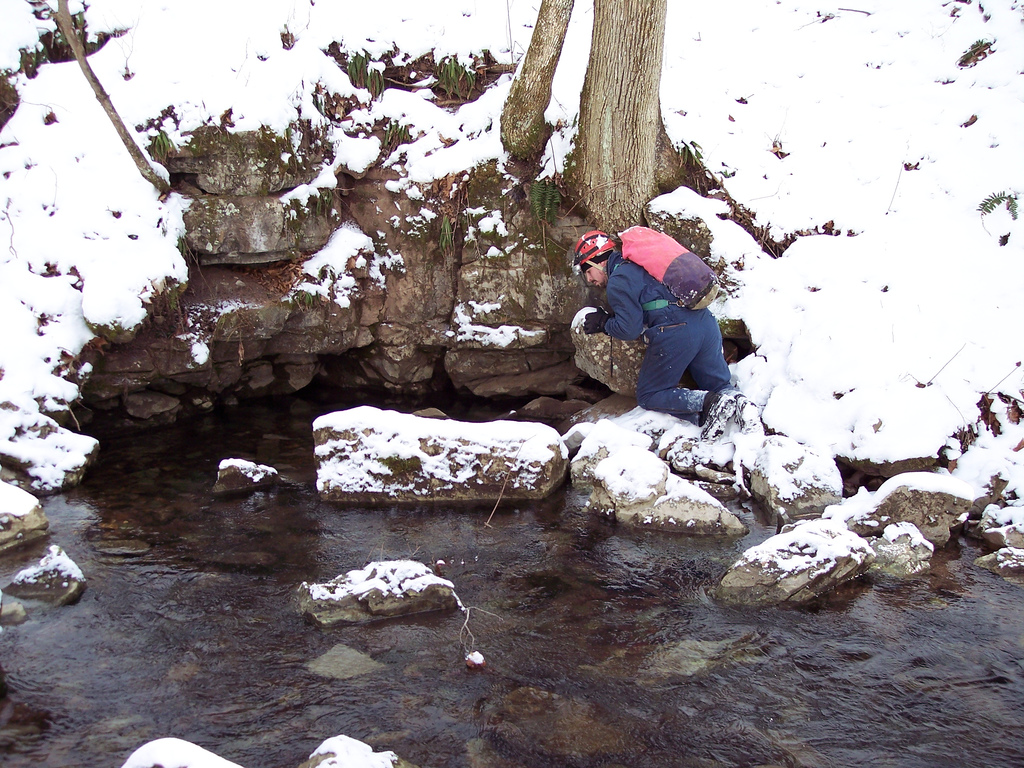
On late Friday afternoon, Jan 19th, 2007, Brian Masney, Mary Schmidt and Dave Riggs went to the Cheat Canyon to do some ridge walking for the Druid/New Years Day Cave system. Dave Riggs has been analyzing the line plots between the Druid and New Years Day Cave systems and something does not look right. It shows the end of the New Years Day Caves and Druid Caves several hundred feet away from each other. We decided to do some ridge walking of our own to see if we could figure out where the problem was.
Brian drove his truck down the Druid Road and parked it right above the cave entrance. We went to the main Druid entrance and got an updated GPS coordinate of the cave entrance. We wanted to make sure that was not the issue. Later on, we found out that the new coordinate matched almost exactly with the original coordinate of the cave. We are also confident with the New Years Day Cave coordinate since it is placed correctly on the topo map.
We hiked across the mountain from the Druid entrance and followed the limestone outcrop. There is a side lead in Druid that has less than a mile of passage in it. Several years ago when Greg Springer and company surveyed the side lead, they found a dead end passage where roots were in the ceiling and some surface debris was nearby. Dave used his GIS program to calculate the GPS coordinate of that location. We hiked around that area in the limestone but we did not find anything interesting. We didn't spend much time on that since that wouldn't help us get any closer to the deeper sections of Druid and New Years Day Caves.
Our next goal was to locate a spot where some surface water goes into New Years Day Cave. This is near the far back of the current survey and it was aptly named the Disney Ride by Dave Riggs. You have to crawl through a small slot near the ceiling where the water just pours onto you from the ceiling. Dave used his GIS program to determine where that should have been on the surface. We hiked to that coordinate and it was located in a stream bed with some water flowing in it. We followed the stream bed slightly downhill and we found a spot where all of the water disappeared underground. There was no viable place to dig. According to the GIS program, we would have to go down about 100' to get to New Years Day Cave.
After that, we hiked over towards New Years Day Cave. One of the GIS maps that Dave has is an elevation model of the state that was generated by a satellite. There is a depression in the main stream further downstream from New Years Day Cave. We wanted to check that out. There are a few waterfalls there and you can see some large cliffs on the other side of the hill. Unfortunately, they are on the opposite side of Lick Run compared to Druid. We did not have time to check these out since we had to be back in Morgantown.
Later that night, Dave looked at the data for New Years Day Cave and Druid Caves. Since we had an accurate elevation of the Druid Cave entrance, Dave was able to enter that data in his GIS program. The vertical line plots between the two caves are still in line with each other, with New Years Day Cave slightly higher than Druid. This is what we want.
The horizontal distance between the end of the two surveys is still pretty far off. New Years Day Cave has over 3,300' of surveyed passage and Druid Cave has 2.31 miles of surveyed passage. There are no loops to close and these are very long surveys. The likelihood of error in the two surveys is very high. A slight error in one survey shot would be compounded in later shots. With that in mind, Dave used the updated elevation of the Druid entrance to determine where the 3D cave passage should lie in the hillside. Our current data shows the end of Druid Cave sticking 70' out of the hillside. If the passage is moved to the left, then it shows the cave passage in the hillside where it should be. This puts it very close to New Years Day Cave.
This is good news. I hope that I have the same enthusiasm the next time I am surveying in New Years Day Cave. I am anxious to get back in there so that we can finish this project.
Wednesday, January 31, 2007
Saturday, January 27, 2007
[trip] Scott Hollow
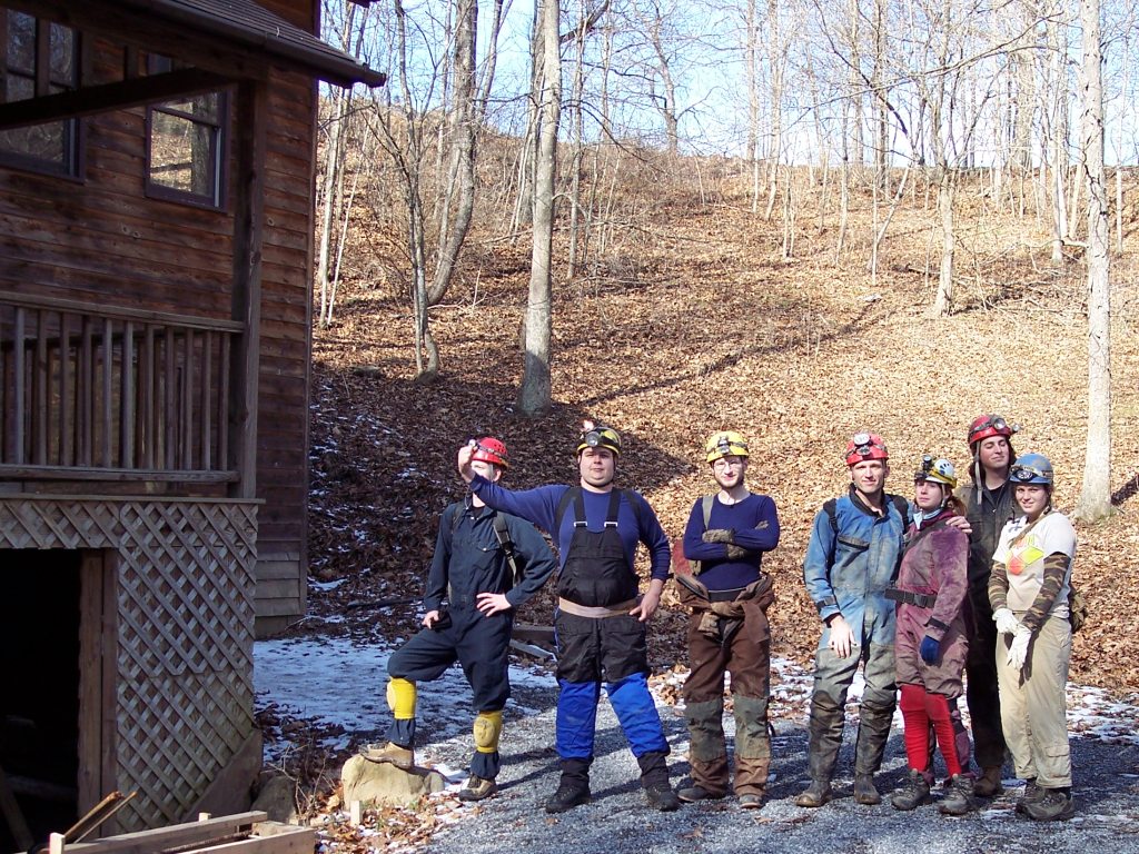
On Saturday, Jan 27, 2007, Ben Mirable, Brian Masney, Mary Schmidt, Kyle McMillan, Ryan Ellers, Ashley ??, and Dave Riggs took a tourist trip into Scott Hollow Cave, in Monroe County WV.
Most of us met up on Friday night at beautiful Casa Mirable, near Pipestem Resort State Park. While Ben had plenty of room for everyone, I chose to sleep outside in the freezing cold to escape Kyle's mammoth snoring. In the morning, we caravaned down to Monroe County.
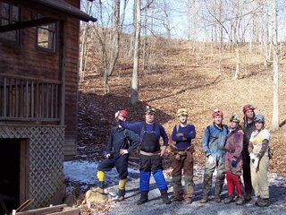
Kyle, Strongman Ben, Dave, Brian, Mary, Ryan, and Ashley outside the entrance house of Scott Hollow Cave.
The entrance to Scott Hollow Cave is located inside a locked house, which is located in the bottom of a giant sinkhole. The owner, Mike Dore, has put a lot of work into the cave since it was discovered in 1984, and also gives paid wild cave tours there. Exploration and surveying are still ongoing, and the cave is currently at almost 30 miles - 3rd longest in WV and 13th longest in the US. A metal culvert with rebar rungs leads about 25' down a windy tunnel into walking stream passage. The limestone dips steeply here, and the passage goes downdip along the Hillsdale Limestone / Maccrady Shale contact, losing over 400' of elevation very quickly.
Within 10 minutes of entering the cave, we somehow managed to become separated from Brian and Mary. Luckily, we managed to cross paths at the Junction Room, where several smaller passages intersect. The group from there continued on until we reached our first destination, Mystic River.

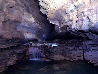
Trunk passage in Scott Hollow's Mystic River. Note the high water mark on the left wall.
Mystic River is a massive trunk passage which appears to be up to 50' wide and up to 75' tall in places, and parallels the strike of the syncline. It appears to be stratigraphically-higher in the Greenbrier (lower Pickaway?), while lower in elevation than the entrance passages (which were in the bottom of the Greenbrier, the blue Sinks Grove and Hillsdale). The water level was in some spots merely inches deep, but for several hundreds of yards we were wading in waist-deep, icy cold water! While the current wasn't terribly strong, the water was deep enough to occlude underwater obstacles like rocks and potholes. The amount of water flowing through there was impressive enough, but to marvel at the amount of water that formed this passage (and hinted at by the high water mark) was mind-blowing! I'm told that this huge passage is itself over 4 miles long, but 1.5 miles are only accessible by sump diving.
We took a left turn at a very large fork and arrived at a beautiful 4' tall double waterfall. As the underground river breaches a layer of chert, it drops abruptly through the limestone; it breaches the chert about 10' upstream as a mid-river sinkhole, with whitewater pouring in from all sides. The sight is quite impressive.
Kyle at the double waterfall.
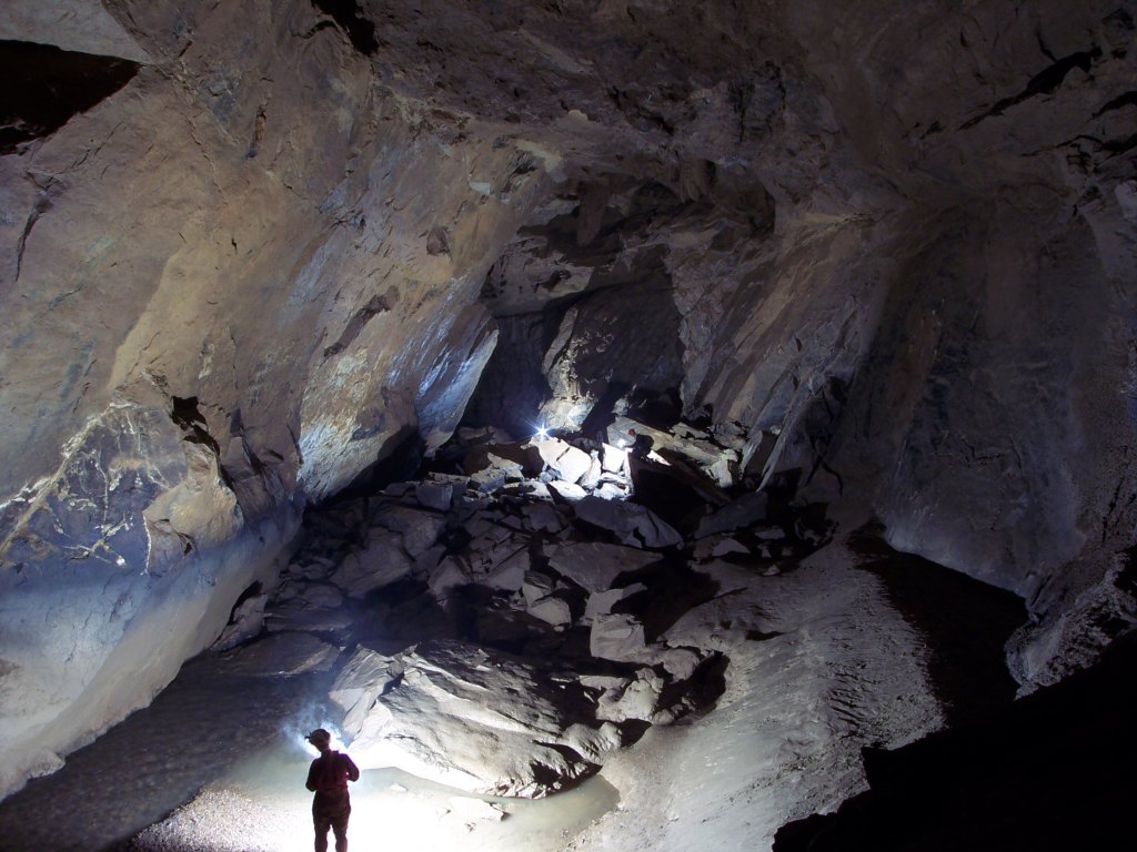
We continued on to the beginning of a section called Iron City, which consisted of a huge hall floored with breakdown and rubble. Our original plan was to attempt a trip to Kansas, but we'd eaten up too much time on the way. We headed back the way we'd come, wading through the waist-deep water, then climbing up the seemingly-endless breakdown hill as we hiked back updip towards the entrance. The climb back out the access culvert seemed twice as long after 7 hours underground.
It was a pleasant surprise to find warm, autumn-like weather waiting for us on the surface, and we were even treated to a lunar halo. After changing clothes, our filthy group headed to the town of Pickaway for some excellent pizza and dessert at the Pizza Barn - highly recommended if you're in the area!
All photos are ©2007 Brian Masney
Access to Scott Hollow Cave is restricted to experienced cavers, who have been NSS members for over a year, and are at least 18 years old.
Most of us met up on Friday night at beautiful Casa Mirable, near Pipestem Resort State Park. While Ben had plenty of room for everyone, I chose to sleep outside in the freezing cold to escape Kyle's mammoth snoring. In the morning, we caravaned down to Monroe County.
Kyle, Strongman Ben, Dave, Brian, Mary, Ryan, and Ashley outside the entrance house of Scott Hollow Cave.
The entrance to Scott Hollow Cave is located inside a locked house, which is located in the bottom of a giant sinkhole. The owner, Mike Dore, has put a lot of work into the cave since it was discovered in 1984, and also gives paid wild cave tours there. Exploration and surveying are still ongoing, and the cave is currently at almost 30 miles - 3rd longest in WV and 13th longest in the US. A metal culvert with rebar rungs leads about 25' down a windy tunnel into walking stream passage. The limestone dips steeply here, and the passage goes downdip along the Hillsdale Limestone / Maccrady Shale contact, losing over 400' of elevation very quickly.
Within 10 minutes of entering the cave, we somehow managed to become separated from Brian and Mary. Luckily, we managed to cross paths at the Junction Room, where several smaller passages intersect. The group from there continued on until we reached our first destination, Mystic River.
Trunk passage in Scott Hollow's Mystic River. Note the high water mark on the left wall.
Mystic River is a massive trunk passage which appears to be up to 50' wide and up to 75' tall in places, and parallels the strike of the syncline. It appears to be stratigraphically-higher in the Greenbrier (lower Pickaway?), while lower in elevation than the entrance passages (which were in the bottom of the Greenbrier, the blue Sinks Grove and Hillsdale). The water level was in some spots merely inches deep, but for several hundreds of yards we were wading in waist-deep, icy cold water! While the current wasn't terribly strong, the water was deep enough to occlude underwater obstacles like rocks and potholes. The amount of water flowing through there was impressive enough, but to marvel at the amount of water that formed this passage (and hinted at by the high water mark) was mind-blowing! I'm told that this huge passage is itself over 4 miles long, but 1.5 miles are only accessible by sump diving.
We took a left turn at a very large fork and arrived at a beautiful 4' tall double waterfall. As the underground river breaches a layer of chert, it drops abruptly through the limestone; it breaches the chert about 10' upstream as a mid-river sinkhole, with whitewater pouring in from all sides. The sight is quite impressive.

Kyle at the double waterfall.
We continued on to the beginning of a section called Iron City, which consisted of a huge hall floored with breakdown and rubble. Our original plan was to attempt a trip to Kansas, but we'd eaten up too much time on the way. We headed back the way we'd come, wading through the waist-deep water, then climbing up the seemingly-endless breakdown hill as we hiked back updip towards the entrance. The climb back out the access culvert seemed twice as long after 7 hours underground.
It was a pleasant surprise to find warm, autumn-like weather waiting for us on the surface, and we were even treated to a lunar halo. After changing clothes, our filthy group headed to the town of Pickaway for some excellent pizza and dessert at the Pizza Barn - highly recommended if you're in the area!
All photos are ©2007 Brian Masney
Access to Scott Hollow Cave is restricted to experienced cavers, who have been NSS members for over a year, and are at least 18 years old.
Saturday, January 20, 2007
Elklick Ridge Walking
The Tucker County Speleological Survey met and spent a cold day ridge walking along Elklick Valley. We spent a few hours tracking down the landowners for permission, then rediscovered some very cool caves, which we'll re-visit when we're more prepared for a wet and vertical trip.

Jason Thomas looks for cave passage in Elklick Spring.
Jason Thomas looks for cave passage in Elklick Spring.
Sunday, January 14, 2007
[trip] 8 Days of TAG Caving
Brian Masney, Garth Dixon, Dave Riggs, Judi Wasilewski, and Mary Schmidt spent part of the week surrounding New Year's caving in TAG.
Tues 26 December: The day after Christmas, I woke at 4 AM to fly home. After arriving, I re-packed for TAG, then met Brian and Dave Riggs for Mexican food. We met Garth at Brian's house, where the three of us spent a few absurd minutes chasing Brian's escaped cat around the parking lot. Cat captured, we finally headed South.
After driving past Wytheville, we started looking at the Gazetteer for possible camping spots near roads dead-ending in National Forest. We set up tents in the snow.
Wed 27 December: In the morning we awoke to bear hunters and their barking dogs. Awakening to hunters was to be a continual theme of our trip... hunting season also influenced our choice of caves, since many TAG caves are on hunting clubs' property and inaccessible during hunting season. After a few more hours of driving, we arrived in TAG. We were hoping to drop Larson's Well; however, the landowner was not home. A neighbor led us to another cave entrance, which had a beautiful sinkhole with a waterfall flowing in. Brian pulled out his laptop to check the GPS coordinates against his database. The cave matched the description of Waterworks cave. We were equipped more for bouncing pits than wet crawls, so we headed instead to South Pittsburg, TN. South Pittsburg Pit was recently purchased and opened by the SCCi. It is a beautiful pit.
We headed to a campsite near Scottsboro, AL, that WV folks have used often for TAG trips: Goose Pond Colony. We set up tents near the lake.
Thurs 28 December:At sunrise, we were awakened by the sounds of World War III (or, duck hunters in close proximity). Later we saw the bumper sticker: "If it flies, it dies."
We headed out in search of 3 pits: Clod Hole, Will Well, and Rhonda Well. We bushwacked for 6 hours without success. Our 1989 directions and GPS coordinates utterly failed us. We were looking for a gully... and an old logging trail. (We found several.) One of Brian's friends had instructed us to find "a grove of cedar trees - but they're common around here"). We stopped at a cave owner's house to inquire about Sawmill Well. He was not home, but his daughter gave us a phone number for future reference. Back at Goose Pond, Dave and Judi soon arrived.
Fri 29 December: A large group of people were planning to camp until New Year's Day at the TAG Cave In site. On the way we stopped at Cemetery Pit. It was pretty, and as evidenced by the elephant tracks and smooth polished rocks inside, quite popular. We wanted to visit the waterfalls (and avoid the map area called "3D maze"), but were thwarted by Ed's Ledge, a 30' drop that required more than a handline. We ran into 2 other cavers at the bottom who told us to look for their caving website; I haven't been able to find it. It would be nice to go back, and also visit Rusty's Pit, located on the same SCCi preserve.
At the TAG site, we met many wonderful TAG cavers, and also ran into Denise and Mike Hopkins, whom Brian met via Flickr.
Sat 30 December: Mike H. took us to Flowing Stone cave, which required a 2-mile, hourlong hike (Brian, as usual, carried the rope the entire time without complaint). Flowing Stone is a beautiful 225' pit. Water flows over a 50' flowstone formation near the top. The floor and walls are also entirely formations.

Dave and Judi at some of the many flowstone formations in Flowing Stone Cave
Originally uploaded by Brian Masney.
Sunday, New Year's Eve: Overnight rain had soaked through our tents and sleeping bags. Wet socks and wet boots were unappealing. We had coughs and chest colds. Dave and Judy headed home. Instead of caving, Garth, Brian, and I spent the morning hiking at Cloudland Canyon. We intended to bounce The Diggings Pit, a 141' pit near the highway. We ended up descending only ~50' to a dry ledge, not wishing to get soaked. The rope was slimed for the rest of the trip. New Year's Eve was spent hanging our wet gear up in a cheap hotel room, doing laundry and listening to trains go by.

Monday, New Year's Day: We had permits for 2 days in Fern Cave, a long beautiful cave system that also includes 404' Surprise Pit. Our plan was to bounce Surprise Pit one day, and spend the next day exploring some heavily decorated horizontal sections. We had difficulty following the trail, thus beginning our daily allowance of bushwacking. We first found the Morgue Entrance (closed), then after more bushwacking, the Twin sinks/Surprise entrance.Surprise Pit was a great rappel, but I'd like to do it in lower water conditions next time. It was extremely foggy so Brian did not bring any photography equipment into the pit.
Do I look pissed in this picture? It's because the cave ate my pack. We rigged in a spot that we had been assured would provide a "completely dry" rappel and ascent away from the 430' waterfall. However, we went during unususally high water conditions. The rope landed at the bottom of a nasty 30' breakdown climb in high winds and spraying water. Brian was the first down and moved the rope so that Garth and I landed at the top of the breakdown pile.
When it was time to ascend, Brian swung out over the pit from the top of the breakdown pile, but his swing was arrested when the rope caught on a rock and jerked him to a halt. Not wanting to slam into the wall when it was his turn to ascend, Garth came up with an elegant solution: I tied myself off to a rock and fed him out on my rack so he could start ascending in the dry part of the pit without having to swing out.
I was the last one up, and had to downclimb the breakdown. It was a tough, sheer climb, complete with "portable handholds" that almost took me with them when they fell. Cavers typically carry garbage bags that can be used as ponchos for water protection -- I tried using one for the first time. It was worse than useless. The wind whipped it up in front of my face, blocking my vision. The climb took forever because I was trying to return the extra ~ 80' of rope slack to its original position at the bottom of the drop (so that it could be pulled up later without snagging on rocks). The rope kept catching on the sharp outcrops of rock and I was continually stopping and backtracking to free the rope.
I started losing my balance while climbing and dropped my pack. It rolled... and kept going and going. I looked for it when I got to the bottom, but it was so coated in mud that earlier in the day, I had been having trouble seeing it from a few feet away. Meanwhile I was getting soaked. The wind was blowing so much water into my eyes that I couldn't keep them open, and I feared losing my contact lenses (I forgot to pack glasses, so I would be screwed for the rest of the week if I lost a contact). I was plenty warm, but ascending in water spray is potentially dangerous, so after fruitlessly searching for a short while, I headed up without the pack. It took less than 50 feet to get out of the water.
If I had to do it over again, I would coil the slack in the rope, attach it to me at the top of the breakdown pile, and swing out into the pit like Tarzan. It would be better to risk a high-speed encounter with the pit wall than do that nasty downclimb again.
I was pleased that I frogged the 404' in 28 minutes -- the tallest pit I have frogged. When we left late that night in the cold and dark, we bushwacked straight down the mountain according to our GPS coordinates.
Tues 2 Jan: We dropped Moses' Tomb, a lovely 230' pit. I used my new Ropewalker system for the first time -- and learned how to downclimb with a Ropewalker after Brian's makeshift flashbulb gun went off in my hand (ouch!) and I had to descend for a new one (a commercial model for smaller bulbs). Unfortunately, the smaller bulbs incompletely lit the pit.
Wed 3 Jan: We obtained permission for Sawmill Well, a nice 155' open air pit. Afterward, we drove home, arriving shortly after midnight. This left us with a few days of vacation to recover from our vacation!
More of Brian's photos are here.
Tues 26 December: The day after Christmas, I woke at 4 AM to fly home. After arriving, I re-packed for TAG, then met Brian and Dave Riggs for Mexican food. We met Garth at Brian's house, where the three of us spent a few absurd minutes chasing Brian's escaped cat around the parking lot. Cat captured, we finally headed South.
After driving past Wytheville, we started looking at the Gazetteer for possible camping spots near roads dead-ending in National Forest. We set up tents in the snow.
Wed 27 December: In the morning we awoke to bear hunters and their barking dogs. Awakening to hunters was to be a continual theme of our trip... hunting season also influenced our choice of caves, since many TAG caves are on hunting clubs' property and inaccessible during hunting season. After a few more hours of driving, we arrived in TAG. We were hoping to drop Larson's Well; however, the landowner was not home. A neighbor led us to another cave entrance, which had a beautiful sinkhole with a waterfall flowing in. Brian pulled out his laptop to check the GPS coordinates against his database. The cave matched the description of Waterworks cave. We were equipped more for bouncing pits than wet crawls, so we headed instead to South Pittsburg, TN. South Pittsburg Pit was recently purchased and opened by the SCCi. It is a beautiful pit.
We headed to a campsite near Scottsboro, AL, that WV folks have used often for TAG trips: Goose Pond Colony. We set up tents near the lake.
Thurs 28 December:At sunrise, we were awakened by the sounds of World War III (or, duck hunters in close proximity). Later we saw the bumper sticker: "If it flies, it dies."
We headed out in search of 3 pits: Clod Hole, Will Well, and Rhonda Well. We bushwacked for 6 hours without success. Our 1989 directions and GPS coordinates utterly failed us. We were looking for a gully... and an old logging trail. (We found several.) One of Brian's friends had instructed us to find "a grove of cedar trees - but they're common around here"). We stopped at a cave owner's house to inquire about Sawmill Well. He was not home, but his daughter gave us a phone number for future reference. Back at Goose Pond, Dave and Judi soon arrived.
Fri 29 December: A large group of people were planning to camp until New Year's Day at the TAG Cave In site. On the way we stopped at Cemetery Pit. It was pretty, and as evidenced by the elephant tracks and smooth polished rocks inside, quite popular. We wanted to visit the waterfalls (and avoid the map area called "3D maze"), but were thwarted by Ed's Ledge, a 30' drop that required more than a handline. We ran into 2 other cavers at the bottom who told us to look for their caving website; I haven't been able to find it. It would be nice to go back, and also visit Rusty's Pit, located on the same SCCi preserve.
At the TAG site, we met many wonderful TAG cavers, and also ran into Denise and Mike Hopkins, whom Brian met via Flickr.
Sat 30 December: Mike H. took us to Flowing Stone cave, which required a 2-mile, hourlong hike (Brian, as usual, carried the rope the entire time without complaint). Flowing Stone is a beautiful 225' pit. Water flows over a 50' flowstone formation near the top. The floor and walls are also entirely formations.
Dave and Judi at some of the many flowstone formations in Flowing Stone Cave
Originally uploaded by Brian Masney.
Sunday, New Year's Eve: Overnight rain had soaked through our tents and sleeping bags. Wet socks and wet boots were unappealing. We had coughs and chest colds. Dave and Judy headed home. Instead of caving, Garth, Brian, and I spent the morning hiking at Cloudland Canyon. We intended to bounce The Diggings Pit, a 141' pit near the highway. We ended up descending only ~50' to a dry ledge, not wishing to get soaked. The rope was slimed for the rest of the trip. New Year's Eve was spent hanging our wet gear up in a cheap hotel room, doing laundry and listening to trains go by.
Monday, New Year's Day: We had permits for 2 days in Fern Cave, a long beautiful cave system that also includes 404' Surprise Pit. Our plan was to bounce Surprise Pit one day, and spend the next day exploring some heavily decorated horizontal sections. We had difficulty following the trail, thus beginning our daily allowance of bushwacking. We first found the Morgue Entrance (closed), then after more bushwacking, the Twin sinks/Surprise entrance.Surprise Pit was a great rappel, but I'd like to do it in lower water conditions next time. It was extremely foggy so Brian did not bring any photography equipment into the pit.
Do I look pissed in this picture? It's because the cave ate my pack. We rigged in a spot that we had been assured would provide a "completely dry" rappel and ascent away from the 430' waterfall. However, we went during unususally high water conditions. The rope landed at the bottom of a nasty 30' breakdown climb in high winds and spraying water. Brian was the first down and moved the rope so that Garth and I landed at the top of the breakdown pile.

When it was time to ascend, Brian swung out over the pit from the top of the breakdown pile, but his swing was arrested when the rope caught on a rock and jerked him to a halt. Not wanting to slam into the wall when it was his turn to ascend, Garth came up with an elegant solution: I tied myself off to a rock and fed him out on my rack so he could start ascending in the dry part of the pit without having to swing out.
I was the last one up, and had to downclimb the breakdown. It was a tough, sheer climb, complete with "portable handholds" that almost took me with them when they fell. Cavers typically carry garbage bags that can be used as ponchos for water protection -- I tried using one for the first time. It was worse than useless. The wind whipped it up in front of my face, blocking my vision. The climb took forever because I was trying to return the extra ~ 80' of rope slack to its original position at the bottom of the drop (so that it could be pulled up later without snagging on rocks). The rope kept catching on the sharp outcrops of rock and I was continually stopping and backtracking to free the rope.
I started losing my balance while climbing and dropped my pack. It rolled... and kept going and going. I looked for it when I got to the bottom, but it was so coated in mud that earlier in the day, I had been having trouble seeing it from a few feet away. Meanwhile I was getting soaked. The wind was blowing so much water into my eyes that I couldn't keep them open, and I feared losing my contact lenses (I forgot to pack glasses, so I would be screwed for the rest of the week if I lost a contact). I was plenty warm, but ascending in water spray is potentially dangerous, so after fruitlessly searching for a short while, I headed up without the pack. It took less than 50 feet to get out of the water.
If I had to do it over again, I would coil the slack in the rope, attach it to me at the top of the breakdown pile, and swing out into the pit like Tarzan. It would be better to risk a high-speed encounter with the pit wall than do that nasty downclimb again.
I was pleased that I frogged the 404' in 28 minutes -- the tallest pit I have frogged. When we left late that night in the cold and dark, we bushwacked straight down the mountain according to our GPS coordinates.
Tues 2 Jan: We dropped Moses' Tomb, a lovely 230' pit. I used my new Ropewalker system for the first time -- and learned how to downclimb with a Ropewalker after Brian's makeshift flashbulb gun went off in my hand (ouch!) and I had to descend for a new one (a commercial model for smaller bulbs). Unfortunately, the smaller bulbs incompletely lit the pit.
Wed 3 Jan: We obtained permission for Sawmill Well, a nice 155' open air pit. Afterward, we drove home, arriving shortly after midnight. This left us with a few days of vacation to recover from our vacation!

More of Brian's photos are here.
Subscribe to:
Posts (Atom)
