Showing posts with label monongalia county. Show all posts

Monday, February 11, 2008

Coal Mine Opened in Morgantown

There's a new "cave" in Monongalia County. It appears to have recently opened up, and is located very visibly next to a main road right inside Morgantown.


A small graded hill, literally on the side of the road, contains a slumped opening about 10 feet wide and 3 feet tall. The ceiling beam appears to be made of a muddy sandstone, while the "cave" itself appears to be formed in a crumbly, shaley seam of coal. The entrance slopes down and back for at least 20 feet and continues out of sight; the passage is at least 4 feet high. Another passage may go to the right from the entrance. The floor is completely covered by shattered coal talus.

My assumption is that this was a very old coal mine which was simply graded over when the area was developed. Recent construction combined with heavy rains this week may have caused the entrance to slump open. It appears rather dangerous, and given its highly-accessible location, should probably be gated or filled very soon.

The helmet in the following photos is for scale only, I did not enter, and I do not recommend entering this mine.


Edit: The mine entrance was posted as state property "no tespassing" a week later, and then filled in by the DoH(?) in early March.

Tuesday, December 04, 2007

[trip] Evening Visit To Maiden Run

On Tuesday evening, the WVUSG took an enjoyable tourist trip to our own backyard cave, Maiden Run #1. Brian Masney, Rich Finley, John Harman, Dave Mason, myself (Dave Riggs), and Anastasia Heasley - on her first outing with the Grotto - met in Sabraton at 6PM, condensed vehicles, and drove out to Deckers Creek. The temperature was below freezing, and there was around 2 inches of snow on the ground - what better time is there to head underground where the weather is always great?


Rich Finley, Dave Mason, Anastasia Heasley, John Harman, Dave Riggs and Brian Masney in Maiden Run Cave #1. Photo by Brian Masney.

Rich headed in first and rigged the 15 foot drop with a cable ladder. He and I descended to the bottom of the first pit, which is about 8 feet in diameter, 25 feet tall, drippy-wet, and intersects the main passage in such a way as to prevent the casual visitor from seeing the majority of the cave. With the aid of a questionable webbing hand-line, I climbed up the far side of the pit and rigged the other side of our cable ladder to the even more-questionable rigging at the top. Rich climbed to the top, then wedged himself into a nook so that he could belay the climbers with a rope attached to his body. Note: One should NEVER rig to any questionable bolts for life support, we chose to do so only because we were able to back up and belay from a well-placed person, and only then because this was an easy "nuisance climb".

Everyone else climbed down and then back up the pit without incident, and we headed further into the cave. We were disappointed to find that most of the "biological speleothems" that we encountered on our last visit had either been carried off or weathered away. We soon popped out and chimneyed down into the second dome-pit, which appears to be about 35 feet tall and 15 feet in diameter. This room is covered in carbide-soot graffiti from the 1950's, 60's, and 70's. It also contains a register which was placed in the cave in 1995, and needs replaced as it has deteriorated extensively.


Dave Mason in the climb-up from Maiden Run's second dome-pit. Photo by Brian Masney.

Brian and Rich set up to take some photos, while Dave, John, Anastasia, and I headed up the dry upper route to push it to its bitter end. Unfortunately the end was quite bitter, as neither Dave nor myself were able to (willing to?) make a tight sideways-squeeze down into a slot with going passage heading off out of sight. Defeated, we headed back to the dome-pit to pose for a few of Brian's photos, taking care not to disturb the well-organized nest of an Allegheny woodrat.

The four of us then tackled the lower stream passage, accessible through a sloping hole near the floor of the dome-pit. Though I'd visited the cave several times, this was my first time down in the stream passage (the stream itself was mostly dry), and I was quite impressed with it. We followed it upstream as an incised canyon, up over a dry paleo bank where the stream meanders under a wall, until it connects back up with the stream. From here, the others followed the stream back downstream into a low canyon, while I continued upstream despite what looked like miserable caving ahead. I crawled for what seemed like approximately 300 feet in very consistent 2 foot high, wide streambed (not so dry), which had a perfectly flat, dipping ceiling, as if the passage were running exactly along the strike of the limestone. After a few moments of pushing, I headed back to the group, convinced that the crawl does in fact continue exactly like that, forever. On the way back to the dome-pit, I pushed an upper lead in the ceiling of the stream canyon, which was very low, very dry, and very disgusting (so this is where those bio-speleothems walked off to!), only to find myself at a dead-end with a dirt plug and a tiny hole. I shined my lamp into the hole and the hole shined back - Brian and Rich were on the other side, I was apparently on a small level in between the high dry passage and the low wet passage, which connects to the dome-pit right behind the rat's nest.

We arrived back at the dome, ate, drank, and planned our exit. John and Rich were to descend last, rigging a pull-down knot to de-rig the cable ladder behind them. Everyone descended the pit and climbed back up the opposite side without incident, and it was John's turn next. He tested the "bomb-proof" rusty rigging and pulled the hanger right off one of our three anchors. Yikes! Having expected issues with the rigging, we had hauled in tons of webbing, etriers, a bit of rope, etc., so within about one half-hour's time, Rich had rigged an etrier and handline to some rocks approximately 25 feet away from the lip. John and then Rich easily came down, back up the far side, de-rigged our cable ladder and headed out. Meanwhile, after they'd safely descended, the rest of us headed back to the vehicles - our wet cave suits frozen solid by the time we arrived. We headed back home at just about midnight, having spent around 4 hours underground on what was an excellent local caving trip.

The WVUSG will be heading back to Maiden Run #1 next week to place new bolts and hangers at the pit, and we plan on teaching new members how to survey by producing a modern map of the cave.

See also: More Maiden Run photos by Brian Masney (including past trips).

Sunday, October 21, 2007

[trip] New Deckers Creek Cave Survey

This Sunday, John Harman, John Cunningham, and I (Dave Riggs) surveyed the new cave near Deckers Creek. We spent about 3 hours surveying, shot 11 shots, including two surface shots in the entrance sink. The cave is 65 feet long and 27 feet deep; the total slope length of our in-cave survey was 99.5 feet. This was John C's first survey trip, and he did great - they didn't have to re-shoot a single shot. It was my first time doing a real sketch, and I can't say that I did as well as the instrument readers - I'm going back next Sunday with a lineplot to re-do my sketch properly!


Dave Riggs sketching (poorly) in the entrance sink. Photo by John Harman.

John C. chimneyed up to the very top of the crevice passage and found that it goes to the very top of the limestone, there is literally topsoil at the ceiling. We moved a few rocks and opened up a second "entrance" to the cave, a 9 inch wide and high joint which intersects the top of the crevice passage. It was large enough to survey through for a single closed loop, but you'd have to be seriously determined to actually go into the cave that way.


John Cunningham looks for a surface opening to serve as a vertical entrance, while Dave Riggs considers trying to go into the slot entrance. Photo by John Harman.

Working names for the cave are "One Room Wonder" and "Three Turkeys", the latter name being a double-play on the three wild turkeys that tried to scoop our cave that afternoon, and on the "three turkeys" who surveyed it.


Plan view of the cave lineplot. The cave is 65 feet long. Generated using Survex.


Profile view of the cave lineplot, showing the vertical extent of the crevice passage. The cave is 27 feet deep. Generated using Survex.


Panoramic photograph of the entrance sink. Photo by John Harman.

Sunday, October 14, 2007

Another New Deckers Creek Cave

I went on a lazy afternoon hike along Deckers Creek this afternoon and located a promising area with a dry streambed that cuts entirely through the thickness of the Greenbrier. With very little effort, I discovered a new cave located up the bank in a narrow, 8-foot deep sink walled by an outcropping of the upper Wymps Gap member. An opening leads down into an entrance room, which is about 8 feet in diameter and 6 - 8 feet high. A fissure passage leads off for about 15 feet and then rounds a turn, beyond which I did not explore (I was armed with nothing but a small pocket light). This area needs to be ridge walked, as it has potential.

Edit: I re-visited this new cave to GPS it, and snapped a few photos. The cave appears to be formed along enlarged vertical joints that combine to form the room at the entrance. The entrance room is about 12 feet at its highest point, with a low lead, about 2 feet high, on the right side. The left side is a fissure passage, up to 15 feet high or higher, and up to 4 feet wide, which goes back for about 15 feet and then appears too tight to follow. The fissure passage bells out at the bottom, and there may be more passage down at that level. The strata looks very similar to that visible in Nuttinbuttawett Pit, which is also formed in the uppermost parts of the Greenbrier; limestone beds are varying shades of grey, blue, and tan, with several containing nice fossils, and a thin layer of tan shale which easily weathers away.


Entrance to the new cave, with helmet for scale.


A portion of the visible strata, showing the weathered tan shaley bed.


Looking down the fissure passage from the Entrance Room. The floor of this passage drops down several feet below the floor of the first room, and bells out at the bottom.


From the Entrance Room, looking up and out into the forest.


The low lead heads off under the entrance from the Entrance Room. It is about 2 feet high, and not as narrow as it appears in this photo.

Tuesday, September 04, 2007

[trip] Travertine Spring Digging

On Monday night I did some solo digging on Deckers Creek, at the spring/FRO that I've named Travertine Spring FRO. I went out again on Tuesday evening with John Harman, who helped move some serious rocks that I couldn't touch on my own. At dusk, two bats flew out of the breakdown where we were digging - one surprised bat bounced off my head on his way out. The cave is named for the chunks of layered calcite (travertine) that have been found in the stream bed, which are hopefully a sign that some serious cave exists inside.

Exciting times we live in...


Travertine chunks found in the streambed of Travertine Spring FRO, Monongalia County, WV.

Wednesday, June 20, 2007

[trip] Deckers Creek Pits

This evening, Brian Masney and I headed to Deckers Creek to "survey" a few pits. Real pits are rare in Northern WV, and even more so in Monongalia County. Several are clustered along Deckers Creek where water manages to enlarge limestone joints and then fall far enough to start cutting down into the rock.

We started with a pit that I discovered last year, called Jumbo Shrimp Pit. Brian rappelled down first, and we taped the pit at 27.1 feet from the lip, 28.5 feet from the bottom of the small sink. The floor has a pile of leaves and debris several feet high. The cave is essentially a single solutionally-widened joint which bells out to 4 feet wide at the bottom. I took a couple survey shots and we both sketched the inside of the cave before ascending out.


Dave Riggs rappels into the (new) deepest known pit in Monongalia County. Photo by Brian Masney.

Next we hiked over to Nuttinbuttawett Pit, which Garton published as 25 feet deep. We dropped the pit and taped it at 19.3 feet from the lip. This cave appears to have formed where two fractures intersect, and an old floor and drain are visible about halfway down. While not as deep or long as the new pit, at least this pit bells out wide enough to form a real room. One thin layer of shaley-limestone had lots of very large crinoid fossils. Luckily the pit was only taking a small amount of water today, so we didn't get soaked. I did a rough sketch of the pit and we climbed back out.


Dave Riggs ascends out of Nuttinbuttawett Pit, after stripping it of its coveted first-place title. Photo by Brian Masney.

Now nearing dark, we spent a few minutes trying to find the pit that Greg Springer described as Itsatightone Pit. Brian found a very small but steeply-walled sinkhole and within minutes had exposed a limestone joint about 8 inches wide in the bottom. We were able to peer at least 6 feet down into it, and could hear rocks bouncing down even further, but it'd take some work and a very skinny caver to push it.


Brian Masney digs open a small sinkhole along Deckers Creek which may be Itsatightone Pit.

See also: Deckers Creek cave photos by Brian Masney

Saturday, June 09, 2007

[trip] Cheat Canyon Work Week Day 2

Today was the second day of the Cheat Canyon work week. Aaron and Tristen Bird, Greg Springer, and I - Dave Riggs - met at Mark's at 9AM, then drove down the hill to his pond to unload camping gear. I was spending only a half-day in the canyon, while the others were camping and working the rest of the week.

At 10AM we hiked down the hill to Lick Run, where we spent the day poking and prodding in the hopes of finding and upstream entrance to Druid Cave. We located the bottom and the top of the Loyalhanna, and found several "interesting" spots, but no definitive places where water is pirated or holes with a vacuum to match the downstream blowing holes. The dye trace definitively says that Lick Run is the source of Druid's water, but we weren't able to find it today. I hiked up the hill at 4PM, everyone else planned on remaining to dig another hour and then call it a day.

Tomorrow the group surveys virgin walking passage in the newly found cave at the extreme downstream end of Druid Cave (past the Twin Springs). I won't be sending out any more trip reports from the work week, as I'll be spending the rest of the week in Mammoth Cave!

Work Week Stats
Surveyed Cave: 96'
New Caves: 1
Virgin Cave: 110'
Participants: 5
Person Hours Worked: 57
Liters of Mountain Dew: 6?

Monday, June 12, 2006

[trip] Biology Study

Bob Griffith and I helped Dr. Daniel Fong and Dr. Horton Hobbs on a biology study this week, cataloguing invertebrate cave fauna. We took them to Beaverhole Upper, Maiden Run #2, and Maiden Run #1 on Monday, then to Beaverhole Lower on Tuesday. I'm now an honorary vertical biologist.


Horton Hobbs, Katie Schneider, Dan Fong, Dave Riggs

[trip] New Years Day Cave Survey

Aaron Bird, Brian Masney, Jason Thomas, and myself (Dave Riggs) made another trip back into New Years Day Cave this weekend (June 10). We first surveyed from the bedrock-on-bedrock crawl, through the Whack-A-Mole™ Way, to the last dig. We then broke up into two teams, and together surveyed through Jason's wormhole, past the dome, past the low/wide stuff, and into the crumbly canyon passage that we last turned around in.

We were in cave about 9 hours and surveyed about 1010', which brings New Years Day Cave to a whopping 2499' length - now the longest cave in Monongalia County (topping Maiden Run Cave #1 at 1800')!


Amazingly, we do this for fun.


The line plot shows NYDC heading directly for the end of Druid Cave, with about 400' straight-line distance between their surveys. We turned around in canyon passage that requires a hammer to continue forward, and the Druid wind is still very strong in this far end of the cave.

Photo by Brian Masney

Wednesday, May 17, 2006

[trip] New Years Day Cave Push

This past Saturday, May 13, Brian Masney, Jason Thomas, Bob Kirk, and myself (Dave Riggs) made another trek into New Years Day Cave. NYDC is believed to be the still-unconnected upstream trunk of Druid Cave. The goal of this push trip was to get past a boulder blocking further progress into the cave - Bob had helped us past similar obstacles at the downstream dig, and was making his first trip into NYDC to help us continue forward.

We met in Morgantown around 9am, drove up to the lip of the Cheat Canyon, and started the trek downhill. All four of us suited up in wetsuits with warm layers over top, carried spare layers sealed up in dry packs, and packed in hand warmers, candles, and a heat tent. Armed for battle with a brutal cave, we headed underground at just after 10:30am.


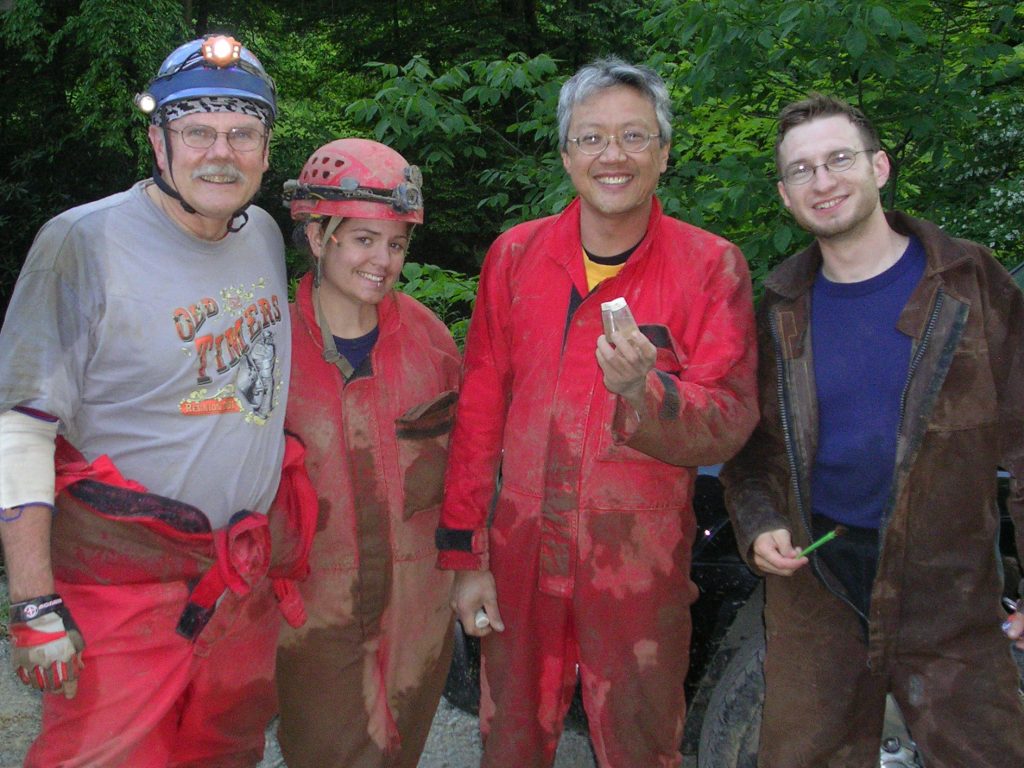
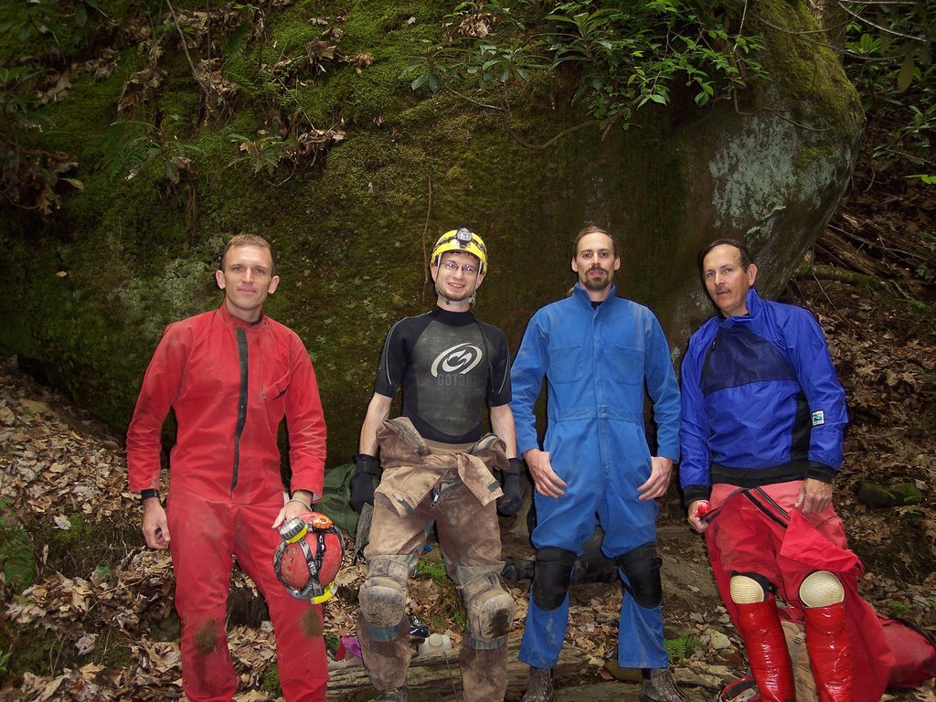
Brian Masney, Dave Riggs, Jason Thomas, Bob Kirk prepare for another relaxing day in New Years Day Cave

Luck seemed to be with us; the water level was low and the moderate temperature outside meant that the cave air was relatively still. Because we were able to stay dry, we actually had to stop and cool off halfway through the sandy "beach" crawl - a wide silt stream bank with a very low ceiling. Everyone was soon soaked after trekking through the cave stream and going headfirst down into a much-loathed water crawl. From here, we did a short jog through the Mon County Borehole and made it to the rock-on-rock-slab crawl at the end of the current survey.

We went ahead and to the Whack-A-Mole™ passage, so named because the finger-like protruding shelves needed whacked with a hammer to comfortably walk through. This was my first time past the last survey station, and I was honestly impressed with the size, the speed we were able to travel, and the distance that this passage covers. For New Years Day Cave, being able to stand upright and walk forward for more than a hundred feet is a welcome treat. I expect the next survey trip to add a good bit of distance because of this passage. Notable here was a large number of shell fossils embedded in several of the limestone beds along the walls.

Finally, after close to two hours(?), we reached our destination: a narrow trench going down from an upper passage to the stream level below, blocked at the very bottom by a boulder just barely larger than the opening it guarded. Jason, Bob, and I started to work on it immediately. Jason and I each drilled a hole, but progress was slow. The passage was apparently blocked with the only sandstone boulder in the entire limestone cave - it would quickly crumble and fill any hole we drilled, while the edges would crumble under the pressure. Meanwhile, Brian suited up, grabbed a shovel, and pushed a parallel lower path in the stream. He made it forward almost to where our boulder was, but was obstructed by more breakdown.

After unsuccessfully trying to tug the boulder out of the way with webbing, it was decided that our best bet against the unwilling rock was to simply pulverize it with the hammer. We easily rounded all the corners, but it was extremely difficult to swing powerful blows in the bottom of the 18" wide slot - progress was again slow. In addition, we were very weary of some sketchy breakdown seemingly balanced on the rocks adjacent to our sandstone foe. We took turns pounding on it, gradually chipping it smaller and smaller, and keeping us from becoming too chilled.

Near 4:30pm we succeeded in rolling the deflated boulder out of the way, leaving a huge mound of powdered rock behind in its place. I squeezed through the opening, being careful not to touch the breakdown on my side, and crawled forward in the stream passage. I shouted back, "It goes... but it sucks!". I went about a body length in and could see that the tunnel shrunk up ahead to painful proportions, with no visible place to turn around. Worse still was the backside view of the sketchy breakdown... the protruding bottom rock itself appeared to be held in place just by the weight of the piles of rock above it. I squirmed out and Jason popped in to confirm that this was at best an obstacle to tackle another day, and given how unstable the adjacent wall seemed, could at worst be the end of the line for New Years Day Cave.

Everyone huddled up above to discuss the situation. Frustrated that this nasty cave could defeat us after all the trips in and out over the past two years, Jason decided to prove to NYDC who was in charge. He went head-first into the sketchy upper "passage", a pile of breakdown supported by breakdown with a roof made of... breakdown. He started pushing and shoving rocks aside, and inching his way forward - head-first, downhill, without room to turn himself around. And after at least 15 grueling minutes of this...
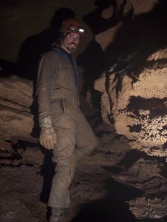


Jason Thomas triumphs over NYDC


...Jason had broken into a virgin room.

We clamored one after one through his wormhole, each of us prying or tossing aside a rock or three so we could fit. The room is about a dozen feet tall, one side frighteningly walled by a mudslide. You drop down to stream level, follow the stream forward a bit and the ceiling becomes lower, to stoop height. A dome, 15 - 20' high awaits, with the first real formation I've seen in New Years Day Cave. From here the stream meanders a bit, the ceiling gets lower and lower, the passage gets very very wide - probably 40' at its widest width, 2.5' at its lowest height.

A couple-hundred feet in, there is a boulder intersection, which we went around and followed the wind down a crawl. Here the passage becomes very different - fingery canyon passage, narrow but 6 - 8' tall, meandering with the water. The "limestone" has a black coating and the fingers can be easily broken off, as if composed of some rotten mud-rock. The Druid winds continued, but we turned back to save the booty for another survey trip.
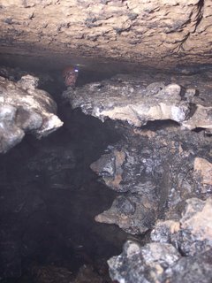


Jason in the virgin canyon passage, note the rotten limestone walls

The trip back out was exhausting. The pointed shelves in the Whack-A-Mole™ passage are shaped such that they poke and grab at every piece of your suit and pack on the way out. We were all coated with sandy mud, and our packs were filled with gear (Bob measured his with a fishing scale afterwards - 50lbs). We finally exited, before dark, scrubbed ourselves off in Lick Run, then hiked back up the brutal hill with mixed emotions. Brian summed everyone's feelings up by saying "Jason, I don't know whether to hug you or kick you!"

Photos by Brian Masney

Friday, April 28, 2006

[trip] Ridge Walking Rt. 7 Part 2

Brian, Jason, and I did some poking around Rt. 7 this evening. We checked out the entrance to Maiden Run #1, found the entrance to Maiden Run #2, and checked out a resurgance and FRO between the two. Both Maiden Run #1 and #2 were blowing cool air.

We then drove down the road a bit and found Nuttinbuttawett Pit, a 20' deep crevice that completely swallows a small stream. The water resurges a few dozen yards down the hill, and looks like it might drop underground again on one side. This area is also peppered with springs and lots of weathered limestone outcrops.


Jason Thomas checks out an interesting karst feature between Maiden Run #1 and #2


Me descending Mon County's deepest pit by hand, Nuttinbuttawett Pit

All photos by Brian Masney

Sunday, November 13, 2005

[Trip] NYDC Work Weekend

This Saturday was a "work weekend" at New Years Day Cave. A record 8 victims volunteers met up at Aaron Bird's house at 9:30am. I almost missed the caravan due to an unwelcome speeding ticket, but made it just in time.

My team - me, Aaron Bird, Doug McCarty, and one of the original discoverers on Druid Cave, Alan Peterson - spent the day continuing the survey. We started the survey just on the other side of the nasty water crawl. We added about 300' to the survey, to just past the long rock-on-rock crawl (which was about an inch smaller than Doug in his wetsuit). A summarizing quote from this survey trip was "David, the next station is this hole in the mud."

We used glowsticks for this survey, and I'm impressed with how well they worked out. The forward and back sight each had a different color so you could use your stick (eg. orange) to light the instruments while easily sighting the other color stick (eg. green). Since they're a line instead of a point, you can align the stick vertically for sighting azimuth and horizontally for sighting inclination. Very handy, but avoid trying to use a dim one!

The other team - Brian Masney, Jason Thomas, Rocky Parsons, and Alan Grubb - went ahead with the intent of pushing the cave towards Druid. They put a good deal of muscle power against some formidable rocks, and weren't able to pass.

The hike up out of the valley was slow and painful for everyone! Afterwards, everyone headed back to Aaron's where Rachel had prepared some awesome bean soup and blue cornbread.