Sunday, December 31, 2006

[trip] Cass Cave

Brian Masney, Mary Schmidt, Jason Thomas, and Dave Riggs took a trip into Cass Cave, one of WV's most amazing (and infamous) vertical caves. We met Saturday night and spent a chilly night camping at Oildrum Falls. In the morning, we grabbed some breakfast at Snowshoe, then headed to Cass. We packed up a ton of photography gear, and a large "emergency pack" in case a sudden weather change caused an extended trip. We hiked up the valley to the cave entrance, geared up, and headed in cave around 11:30am.

Brian and Jason headed in first to haul gear and rig the drop. Mary and I followed with the remainder of the gear. The entrance passage was relatively dry, but we still managed to get our arms and legs wet in the stream crawl. We met back up at the climb to the belay loft, passed our gear up to the top, and climbed into the windy upper passage. Brian chimneyed out and picked the two best of the available four bolts, and backed up with a safety traverse line back on solid ground. To get one rope, one must slide out across a slick ledge for about 8', and then shimmy down into a narrow canyon where the bolts will keep rappellers safely out of the spray from Suicide Falls.

The 180' rappel takes you down about 30' against walls and ledges, then it's a free rappel into a huge room... Suicide Falls crashes down on one side, the other overlooks a giant mountain of breakdown with an enormous boulder wedged between both walls, frozen in mid-tumble. After you climb the breakdown pile, the enormous borehole passage stretches as far forward as you can possibly see. We set up the gear for some photography of this amazing passage.

Brian, while incredibly skilled in photography, is not nearly as well known for his electronics skills... and for good reason. Brian constructed several flash guns using radio shack parts, duct tape, and cardboard. He handed these fine units out to his unwitting sherpas and sent us all out into the borehole passage to try and light it up. As I screwed my first flashbulb into the untested flash gun, I heard a loud pop, my vision went completely white, and felt a sharp pain in my ungloved fingers as they were singed by the magnesium flashbulb. Brian helpfully recommended that I "make sure that I'm not pressing the button" on the gun, and then suggested that I contribute to the photo by screwing the next bulb in on the count of "three" (to which I very politely replied "NO.") I made him screw the next bulb in, and it worked correctly, giving me a false sense of security. I tried another and was rewarded with yet another pop and the stench of melted neoprene glove.

We headed further on into the cave to check out some amazing rimstone dams and the birdbath formation, as well as lots of great bacon and flowstone on the walls. A lower passage leads to a pristine lake surrounded by formations, which we didn't go near for fear of messing it up with our filthy boots.

Cass Cave "big room", photo by Brian Masney.

William E. Davies

Unless you just crawled out from under a rock, you've most certainly heard of William E. Davies. Davies authored Caverns of West Virginia for the West Virginia Geological and Economic Survey, published in 1949. This book has been the most popular title ever put out by the WVGES. The WVGES received so many requests after it had sold out that the book was revised and re-issued in 1958, this volume completely selling out within 6 years. Demand was still so high that the book was again re-issued, along with a supplement, in 1965. The work that Davies did for Caverns was the inspiration for WVaSS. That's probably the extent that most West Virginia cavers know about Bill Davies.


W. E. Davies, photo from the National Cave and Karst Research Institute's Davies biography

Davies (NSS 345) was President of the National Speleological Society from 1954-56, and served as Science Vice President from 1951-53. He was chairman of NSS Research Advisory from 1951-53, and the editor for the Bulletin (precursor to the Journal of Cave and Karst Studies from 1957-63. He is listed as one of the original three of the board of directors and one of the original seven of the board of trustees from the NSS articles of incorporation. He was awarded Certificate of Merit in 1950, became an Honorary Member in 1960, and an NSS Fellow.

W. E. Davies passed away in 1990, but the efforts he helped put in motion live on today.


http://www2.nature.nps.gov/nckri/map/maps/engineering_aspects/davies.htm

http://www2.nature.nps.gov/nckri/map/maps/engineering_aspects/text.htm

http://water.usgs.gov/ogw/karst/kigconference/rco_proposedmap.htm

http://www.caves.org/nss-business/bog/app-c.html

http://www.caves.org/nss-business/bog/table-4e.html

Sunday, December 10, 2006

[gis] GIS Data For Cavers

This posting is an index of places to find GIS data relevant to cavers. The following location-specific depots should have topographic, geologic, hydrologic, etc. data in some usable raster or vector format, and the data should be available for free. I'll try and keep this list up to date as I become aware of more relevant sources.


West Virginia:


Tennessee:


Alabama:


Georgia:


Virginia:


Kentucky:


Canada:


General:

Wednesday, November 22, 2006

[trip] New Years Day Cave Survey

Ben Franklin is often attributed to saying:

"The definition of insanity is doing the same thing over and over and expecting different results."


Brian Masney, Dave Riggs, and Jason Thomas are insane. On Saturday, Nov. 18, we headed back into New Years Day Cave again with the hopes of making the elusive connection with Druid Cave. Once again we hoped that this time would be different, and once again the cave got the best of us.

Druid Cave, with over 2.3 surveyed miles of crumbling, muddy passage, has a much-deserved reputation as one of the nastiest caves in West Virginia. In fact, some would consider it an evil cave. When the 8+ hour travel time for survey trips finally became too taxing, the Druid surveyors began looking for an upstream entrance to the cave to make their lives easier. What they found was New Years Day Cave, which has proven to be anything but easier. If Druid was the frying pan, NYDC is the fire.

The three of us met Saturday morning at the rim of the Cheat Canyon. We packed all our gear and started the hike down into the gorge. A weeklong rain had Lick Run roaring with more water than I'd ever seen it move. We suited up into wetsuits and our caving coveralls, packed extra fleece polypro underwear, heating pads, candles, and emergency gear. We not only prepared for the worst, we expected it.

We were in cave before 11am, and were relieved to find the cave stream in the first part of the cave to be at a reasonable level. We moved fast and tried our best to stay dry on the way in. Our goal was to reach some "large" paleo-passage discovered on the last survey trip, in the deepest depths of the cave, where NYDC is known to be at its closest point to Druid Cave. We stormed through the beach crawl, down through a horrible wet crawl, squeezed through the rock-on-rock, dropped down into the sawtooth-lined Whack-A-Mole™ Way, squirmed through Jason's wormhole, dragged ourselves across a wet bedding plane parting, and made our way into another horrible canyon passage. The black rock in this section of the cave will crumble without warning beneath an unsuspecting caver's feet. Water pours in from the ceiling onto your head while the passage meanders into such contortions that it seems to be trying to evade you.


Jason's cave suit, literally shredded by the sawtooth walls before we'd even reached our destination.

After several hundred feet of this hellish passage, we climbed up to the ceiling and crawled through a very nondescript, nearly overlooked squeeze to a parallel passage with a decent-sized, dry, open room. I was amazed. Even more amazing was that this room led to hundreds and hundreds of feet of more dry, open, large passage! We had made our way into a parallel grid of joint-controlled passages, sometimes as wide as 20' with a 20' canyon incision. There were flowstone and drapery formations, the floors and walls were coated with a thin film of mud, but there was no moving water in sight. A cobble-lined stream bed lies in the canyon floor, and very large slabs of breakdown have tumbled down in places. Unfortunately, there was no air movement in this section. We pushed in the upstream direction until our first joint squeezed out, then followed a 90° connector over to the next parallel joint and pushed it for a bit, finding a 30' high dome and lots more mud. Still, no air.

We exited this beautiful passage and crawled back into our stream canyon to follow the air. At this point, the canyon follows the straight-line path and direction of its neighbor passages, as a part of this master joint set. The canyon tightens up, leaving a 12" by 18" tunnel up towards the ceiling, with 10' of narrow, terrifying canyon reaching down below. With no way to go at the bottom, the top was our only way forward. This crawl was certainly too narrow to turn around in, and the canyon below with the crumbling rock walls and floor made it especially dangerous.

I reluctantly volunteered to go in, on the condition that Brian follow me. We started in, pulling our bodies with our fingers and pushing with our toes. The canyon in the floor kept sucking in feet and kneepads, the passage was so narrow that I couldn't turn my head or put my arms back at my side. I crawled for perhaps 50' in the hopes of finding a slightly wider spot, but the passage maintained its torturous dimensions. I shined my StenLight forward and saw nothing but blackness far ahead -- if this passage parallels the larger joint-controlled passages to the side, it could stretch for hundreds and hundreds of feet. More than a bit spooked by the confinement and the thought that a rescue this deep into the cave would be nearly impossible, I decided that I would not go any further. We started the arduous task of backing out, pulling with toes and ankles, pushing with fingertips attached to helpless outstretched arms. It was a long, tiring haul back to passage of kneeling height.

Disappointed with this failure, we opted to survey for a bit in the large, dry passages. We took some time to eat and rest, changed into warmer clothes, and surveyed some nice long shots. Due to how physically exhausted we were, along with time constraints, we surveyed only about 250', leaving many hundreds of feet more to be surveyed and explored in this network of passages. These tall canyons could lead us to a more promising upper or lower level, or they could somehow bypass the nasty canyon crawl that kept us from following the Druid Winds.

On the way out, we no longer cared about trying to stay dry. We barreled out of the cave at record speed while the cave did its best to slow us down. We reached the surface one hour and forty-five brutal minutes later, but New Years Day Cave had the last laugh. The Druid Spirits were especially tough on Jason, his cave suit was literally ripped in half, StenLight was out, his carbide lamp working only in fits. My suit was torn in the shoulders, legs, and knees. All of us were physically beat, we were soaking wet and coated from head to toe with mud, and the temperature outside was in the upper 30°'s. We still had to hike up and out of the Cheat Canyon.


To say that the trip was exhausting would be an understatement. We were in cave for about 11 hours, New Years Day Cave time; this probably equates to days in "lesser" caves. The Druid connection eluded us again, NYDC proved to be every bit as horrid as it has in the past, and everyone involved was ready to swear off caving for good... but we know that next time will be different.

All photos by Brian Masney

Wednesday, November 08, 2006

[trip] Beaverhole Upper

After a day of brutal ridge walking in the Cheat Canyon, I met up with John Cunningham, John Tudek, and first-time caver Nicole Bodkin at 5pm. We drove down through Pisgah and into the Cheat Canyon, geared up and headed into Beaverhole Upper Cave. There was no shortage of water flowing through the cave this evening; the back passages had insurging water pouring down from the ceiling and infeeder crevices, the back side was full of leaves and sticks. On the way out, I discovered a brand new room which John T noted as looking suspiciously identical to the previous room.

Afterward, noting all the washed-in debris in the back of the cave, we tried to find the insurgence point in the stream down the road, but the dark and the abundance of leaves on the ground kept it hidden from us. We were back home at 9:30pm. Everyone had a good time and Nicole is eager to go caving again soon.

Ridge Walking in the Cheat Canyon

Kyle McMillan, Gayle Suppa, and myself -- Dave Riggs -- did some ridge walking down in the Cheat Canyon on Election Day. We met at 10am at Coopers Rock, then hiked the trail out to Raven Rock. From there, we followed the power line cutaway straight down into the gorge. This canyon is incredibly steep! Though the forecast called for rain all day, we had a beautiful day with nothing more than a few sprinkles.

After somehow passing right over the limestone outcrop, we continued down to a sheer vertical drop just a few hundred feet from the river itself. We'd gone too far, and started hiking over to a stream falling over a sandstone shelter cave.


Gayle under the shelter cave. The stream flows down from Beaverhole Lower Cave.

We followed this stream straight up the hill and, as expected, found it to be the stream resurgence of Beaverhole Lower Cave. We spent about 45 minutes in Beaverhole Lower, traveling back in it's single straight-line passage until we were sufficiently bored. Some of the walls are polished smooth from all the caver traffic back in the 60's and 70's, as evidenced by the old signatures back there. Hard to believe that so many people made this brutal hike down for such a boring cave. If nothing else, the cave is interesting in that there are no side leads or tributaries, it's just a single passage extending at least 1300' straight into the mountain.


Kyle and Gayle at the entrance to Beaverhole Lower Cave

Then we followed the limestone outcrop, hoping to find something new and exciting. Travel was very slow as the terrain was extremely steep and slippery, at some points bordering on dangerous. We found a 40' high limestone cliff with a 2' - 4' diameter cave passage up in the cliff, but weren't able to safely get close enough to check it out. Vert gear will be required to investigate it.


Limestone cliff with small cave passage visible up towards the top/middle

We traveled a bit farther, just enough to spot a very large valley and an 80' tall waterfall over a limestone cliff in the distance. It's enough to make me want to brave the brutal hike through the canyon again to check it out. We were back to Morgantown by just after 4pm and had a well-deserved meal at IHOP. We then met the WVUSG at 5pm and I went with them to Beaverhole Upper.

See: My Photos

Thursday, November 02, 2006

Raese on Vampire Bats

Republican WV Senate candidate John Raese was interviewed on PBS's Outlook show on Oct. 12. Raese is CEO of Greer Industries, the only group of people who get more excited about limestone than cavers do. The following excerpt from the interview is Raese talking about the sorts of government regulation he'd like to do away for the benefit of small business (like his own):

I sit around and battle the endangered species act when I have to sit around and follow how many vampire bats are in a quarry that I have -- send two people down to see how many vampire bats we have. Is that a good law?


He is likely referring to those pesky endangered "vampire" bats in that derned Hellhole Cave (15th longest cave in the US, home to 45% of the world's population of Virginia Big-Eared Bats). The entire interview is full of great quotes, and I recommend that all West Virginians of voting age read the transcript in full. More info on the issue with Greer and Hellhole is available here.

Update: Raese lost.

Thursday, October 26, 2006

2006 Bridge Day Rappel

Monongahela Grotto Team Photo Gallery from the 2006 Bridge Day rappel.


Jason Thomas rappels off the New River Gorge Bridge. Photo by Don Ferguson.

Thursday, October 12, 2006

[trip] Caving in TAG

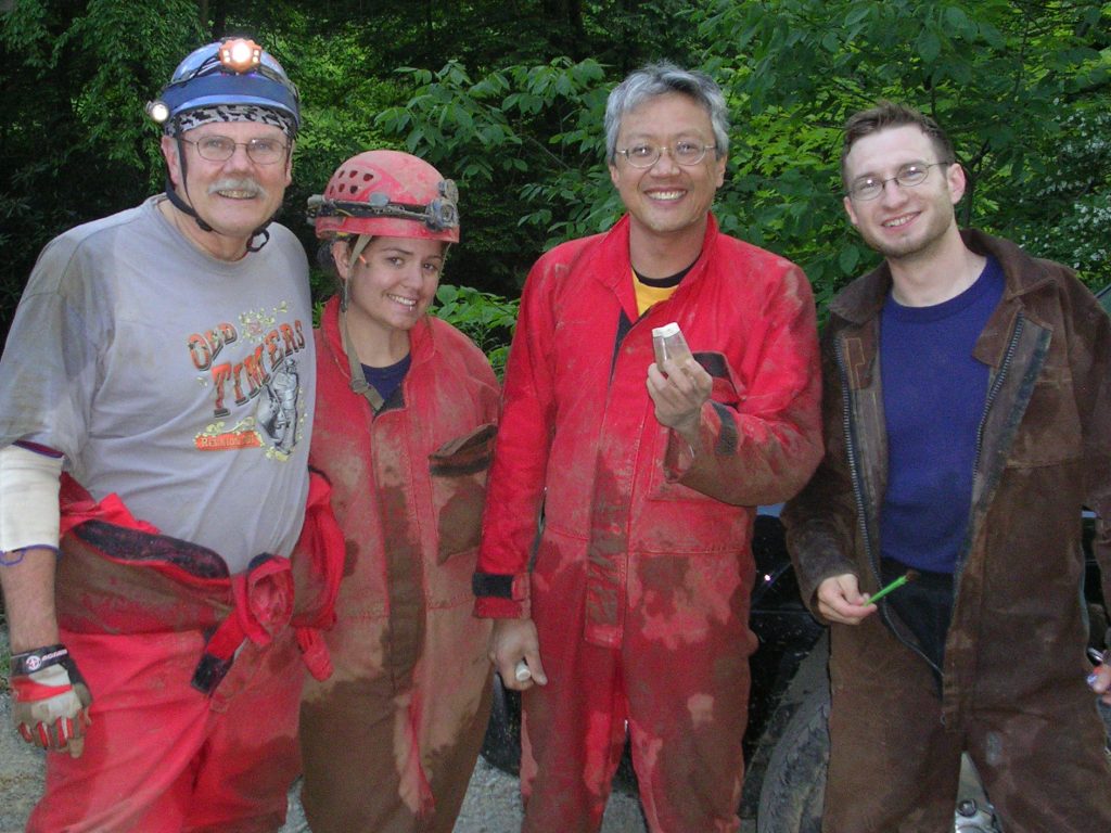
On Oct. 5 - 8, Brian Masney, Mary Schmidt, Judi Wasilewski, and Dave Riggs took a trip down to TAG to drop some classic pits. Our original plan was to photograph Fantastic Pit then head to the TAG Fall Cave-In, but we decided to skip the Cave-In entirely and squeeze in as much caving as possible instead.

We hit the road from Morgantown at about 2pm on Thursday and headed South. We met Judi in VA, and then headed down to the tip of Georgia. We finally pulled into the Crockford Pigeon Mountain Wildlife Reserve just after midnight, set up camp and went to bed.
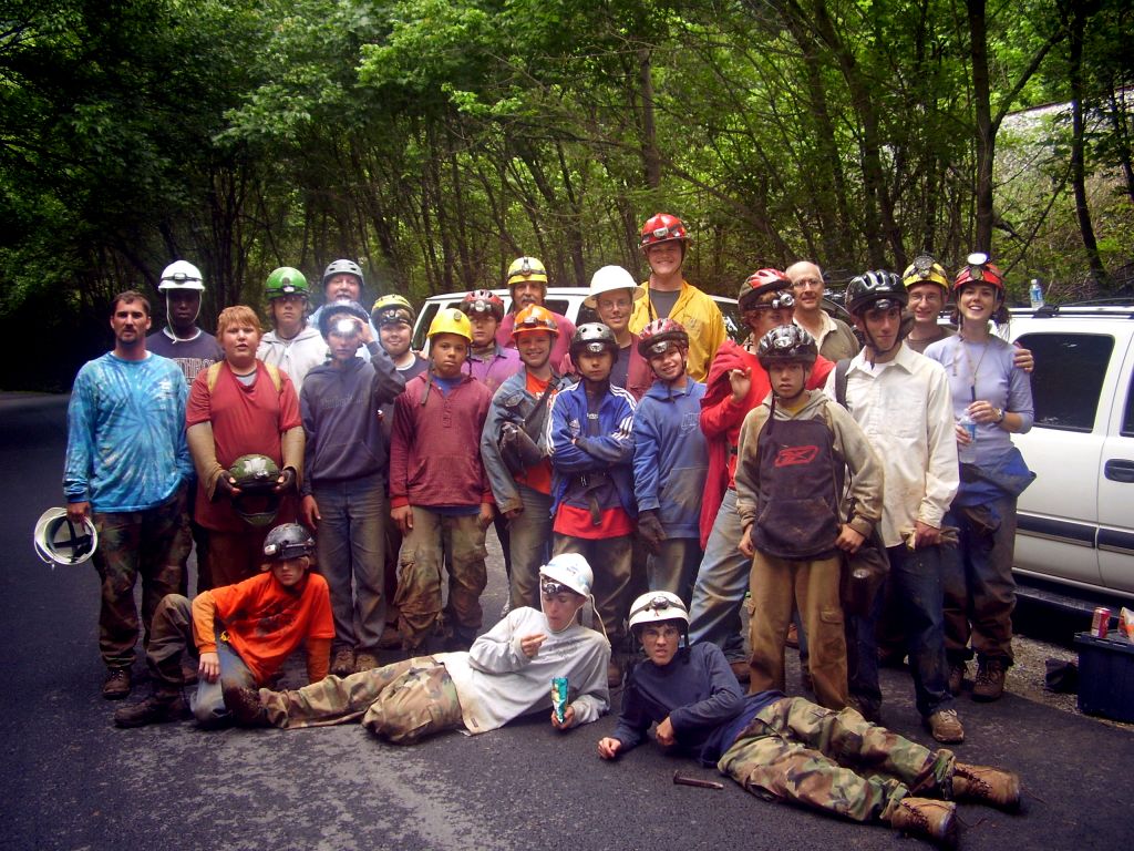
Day 1: Ellison's Cave

We woke up early Friday morning and gathered up all our caving gear. A second, larger caving group showed up as we were getting ready to leave, but they were a bit less organized than we were. The trail up to Ellison's Cave starts down at Blue Hole, the cave's resurgence. The hike is over a mile uphill, and this hike is exhausting when you're loaded down with gear and rope.


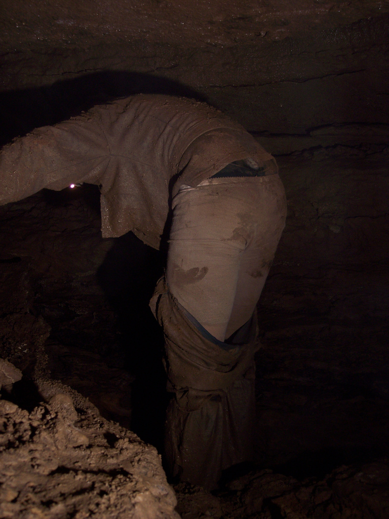
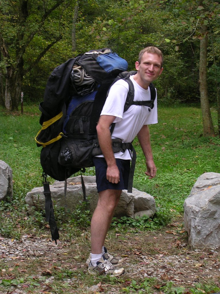
Brian ready to hike up Pigeon Mountain with 900' of rope in tow


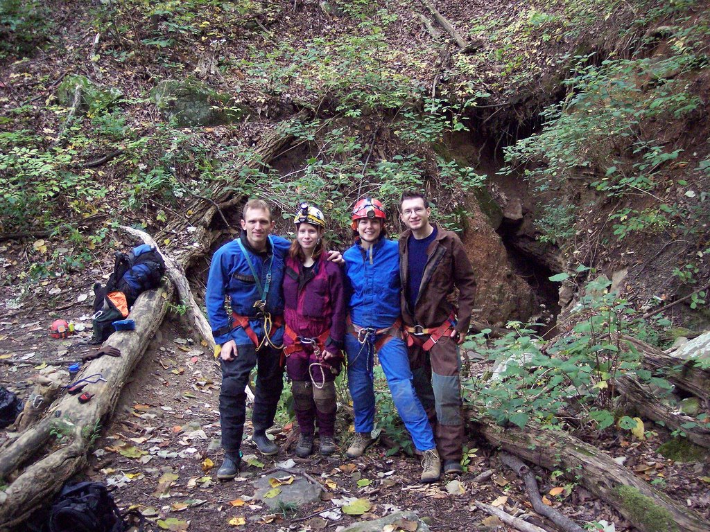
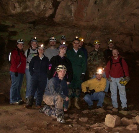
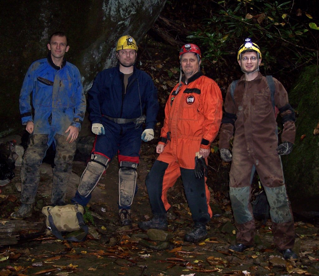
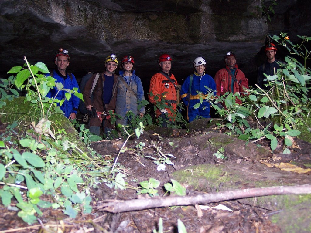
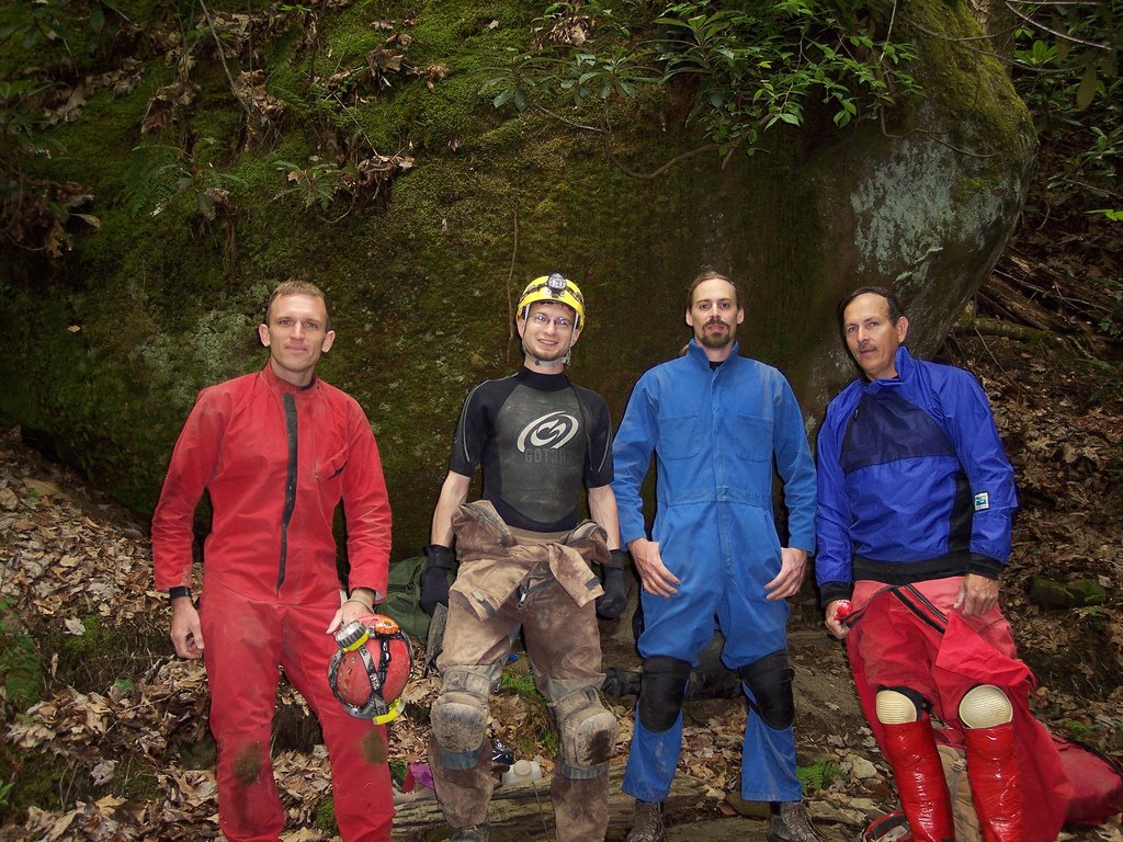
Brian, Mary, Judi, and Dave at the entrance to Ellison's Cave

We reached the unimpressive crack-in-the-ground which is the preferred entrance to do Fantastic Pit and got dressed. After a climb-down, the cave consists of nice walking stream passage (very dry this day) called The Ecstasy, which leads to the 120' Warm-Up Pit. We rigged from a couple bolts in the ceiling and ran our rope through some deep rope grooves worn into the rock, no rope pad necessary -- hooray for PMI. From the Warm-Up Pit, you head up a few nuisance climbs, then to a 20' ascent. From here, it's a short path to a traverse line under a short ledge to The Attic, looking out over Fantastic Pit.

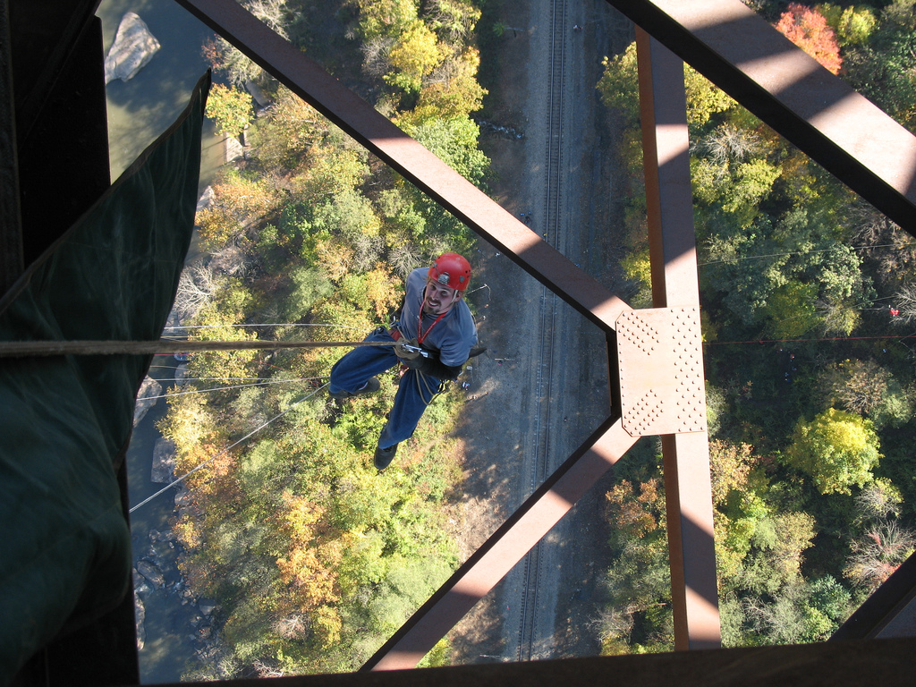
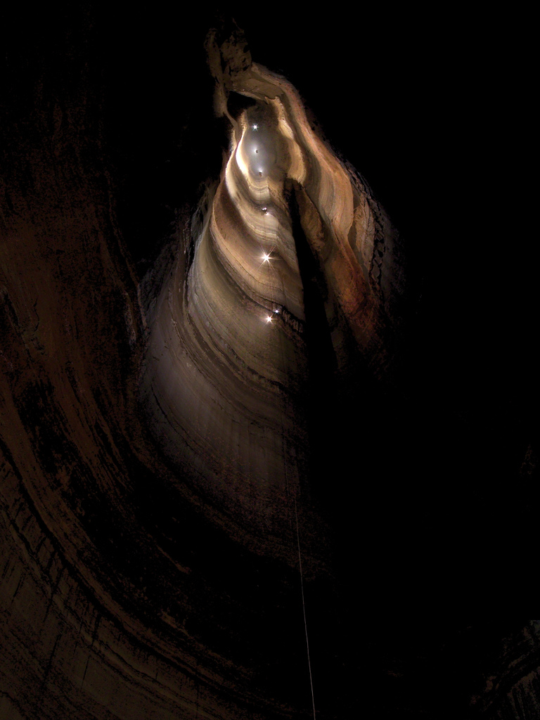
Fantastic Pit is the deepest known pit in the Continental US, a 586' free rappel down a beautiful vertical-walled shaft. We rigged our 900' rope to a massive boulder, tied a knot in the end, then lowered most of it down using a rack to keep it at a safe speed. Brian repelled down first, occasionally shouting or whistling to hear the amazing echo. All of a sudden we heard him shout "F@#%!" and everything went quiet as we all felt our stomachs sink... Brian radioed up that he was hanging 40' off the floor but had reached the knot at the end of the rope. We'd just barely short-rigged the pit. Rather than risk being lowered from above, he changed over and ascended back up. Even though his foot ascender broke on the way, he still made it to the top in what seemed like record time.

We re-rigged the rope, and this time I was the guinea pig to try it out. The ride down seemed to take forever, and the amazing reverberating echo from the pit was absolutely haunting. I finally reached the bottom of the shaft, got off rope, and discovered that my cheap radio no longer worked. Communication from top to bottom is practically impossible without one, and Judi was halfway to the bottom before I knew for sure that she was on rope! One by one, the rest of our team made it to the bottom and got ready for a long wait and a long ascent. I was the first to ascend back out, and was admittedly nervous about it. Not only would I be the first one up our only rope, the biggest ascent I'd ever attempted, but I'd be also be helping Brian photograph the pit by firing off several flashes on the way up.

Brian gave me a quick lesson in the operation of a flashbulb. I was to screw the bulb into the trigger without looking at it, wait for the signal, then look the other way with my eyes closed and fire the unit away from me to ensure that I didn't lose my sight. Oh, and I should also be careful since they sometimes explode if they come in contact with water. Great. I started frogging up at a very slow pace -- the rope would bounce more than 10' with each stride. Every 30 or 40 strides I'd stop and dig through my duffel bag trying to find a fresh flashbulb, arm it, and fire off a shot for the camera. Even with all the breaks, I managed to get incredibly hot and dehydrated. The climb seemed like it took hours.


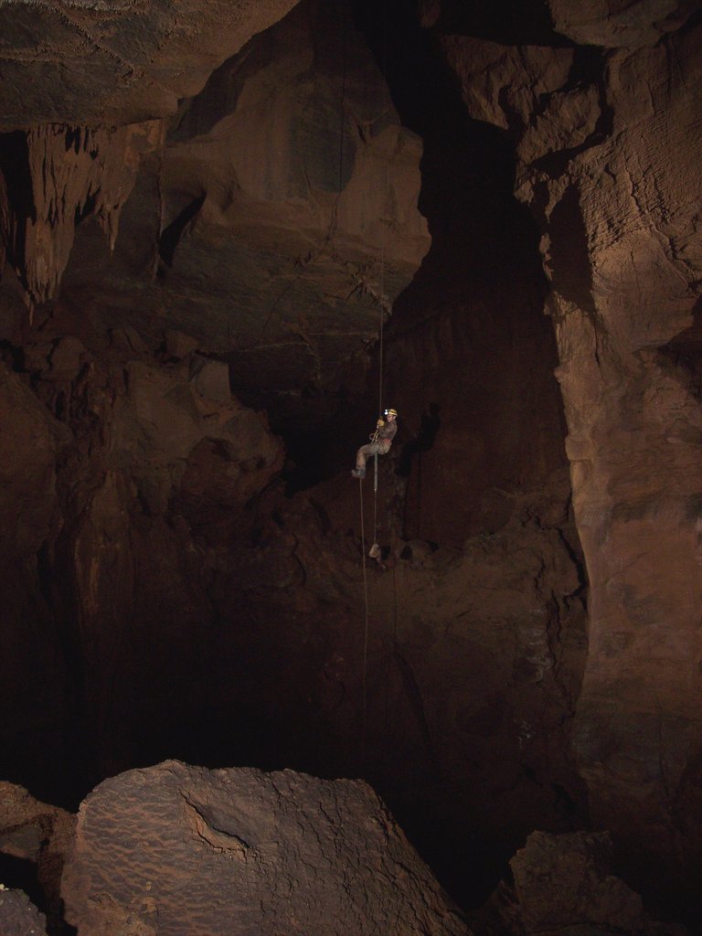
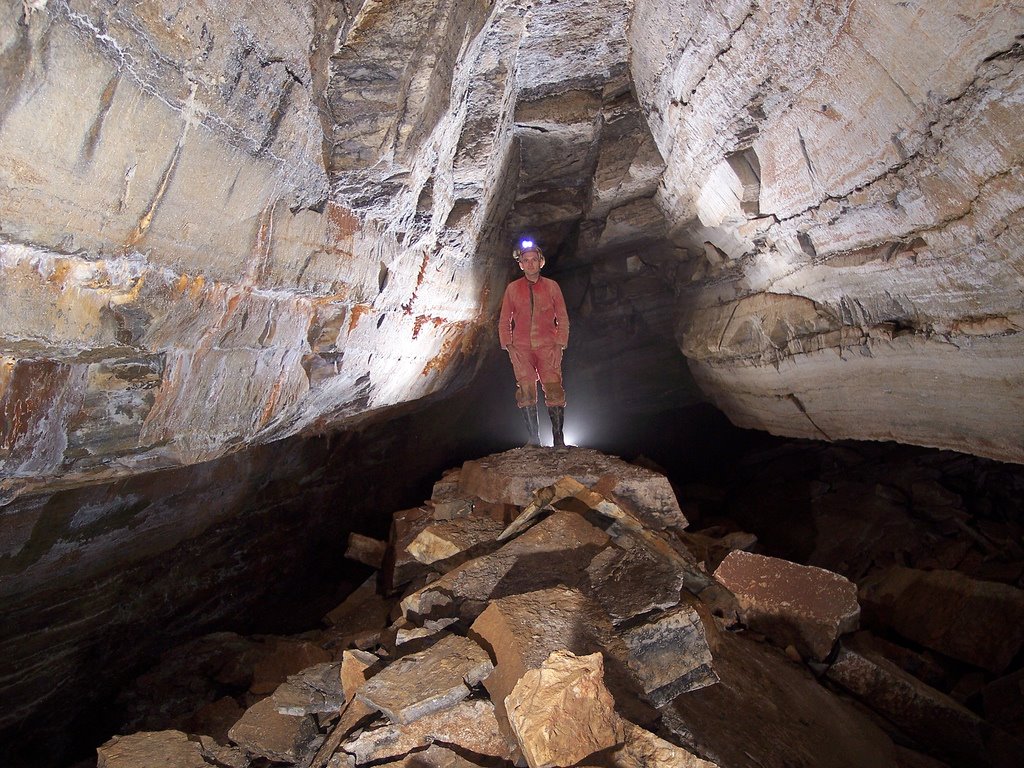
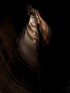
A composite of 10 different individual photos and the result of hours and hours of cave photography, Brian's photo of Fantastic still can't do justice to how enormous this pit is.

Judi headed up next, also armed with a few flashbulbs to light up the rest of the pit. She and Mary flew to the top with their ropewalkers, then Brian frogged back up a second time loaded with all his photography gear! Pulling the rope back up was a huge effort, as was hauling the damn thing back out of the cave -- it's amazing how much your rope and gear expands when you're trying to get back out of a cave. Back down the nuisance drop with that monster rope, and then back up the Warm-Up pit, and then derigging the Warm-Up pit, and then hauling everything back out... we were exhausted, and not looking forward to the hike back down the mountain. We opted to dump our ropes at the cave entrance and hike down lightly, a hike that seemed to have doubled in length since the previous morning. We finally made it back to camp at 4am, after a long but incredible day of caving. After a good breakfast in the morning, the hike to retrieve our ropes seemed like a piece of cake. We found a fraction of the other caving group getting ready to go back in, they had showed up to finally rappel Fantastic -- they'd run out of time the previous day and half of their group had abandoned the trip; the poor remaining three cavers would have to haul the entire party's gear and ropes back out on their own!

Day 2: Neversink Pit

We left Georgia that afternoon and headed to Alabama to drop another TAG classic, the 162' Neversink Pit. We took a quick detour to check out the nearby rock zoo, then parked and geared up. Everyone hiked up the hill and found over a dozen cavers there -- TAG Fall Cave-In traffic.


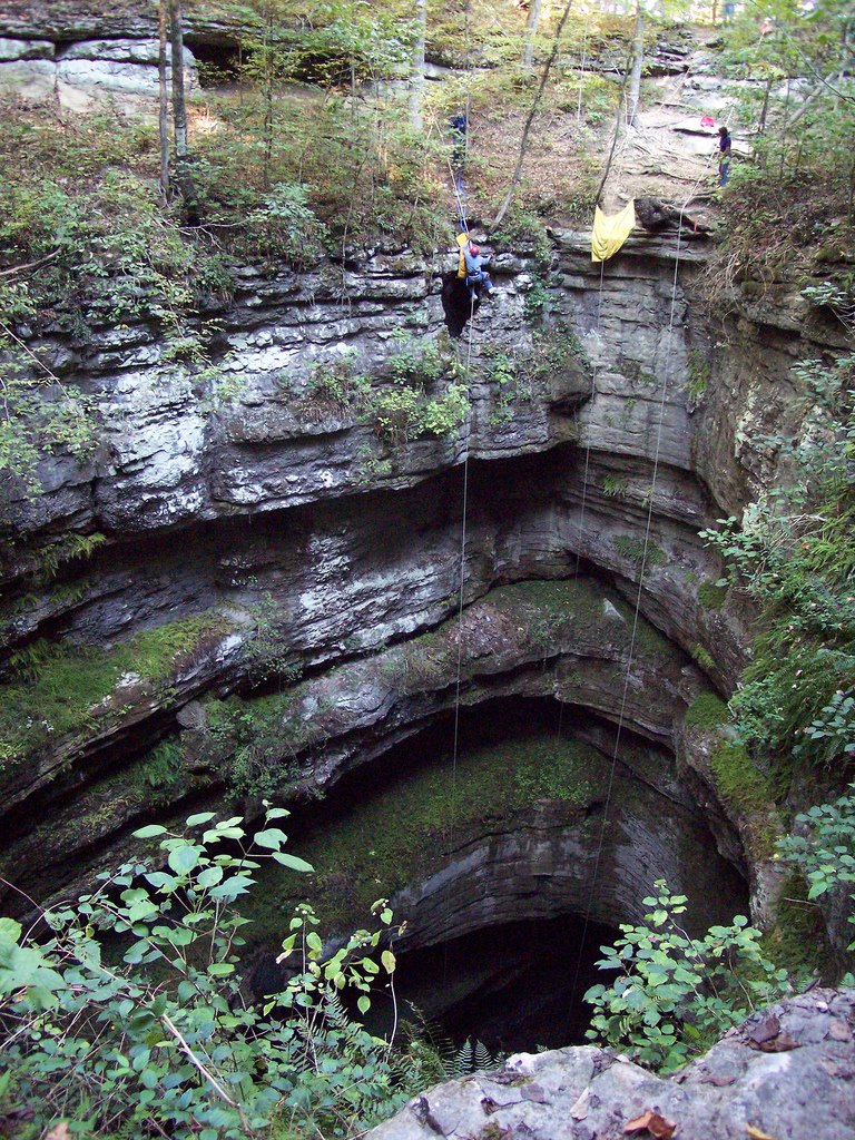
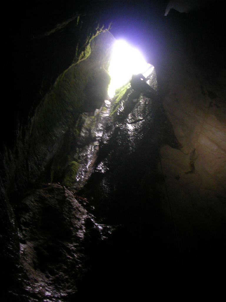
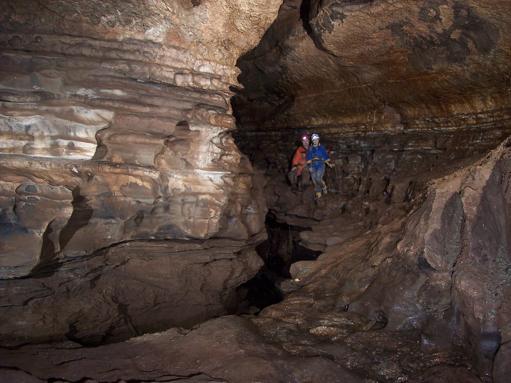
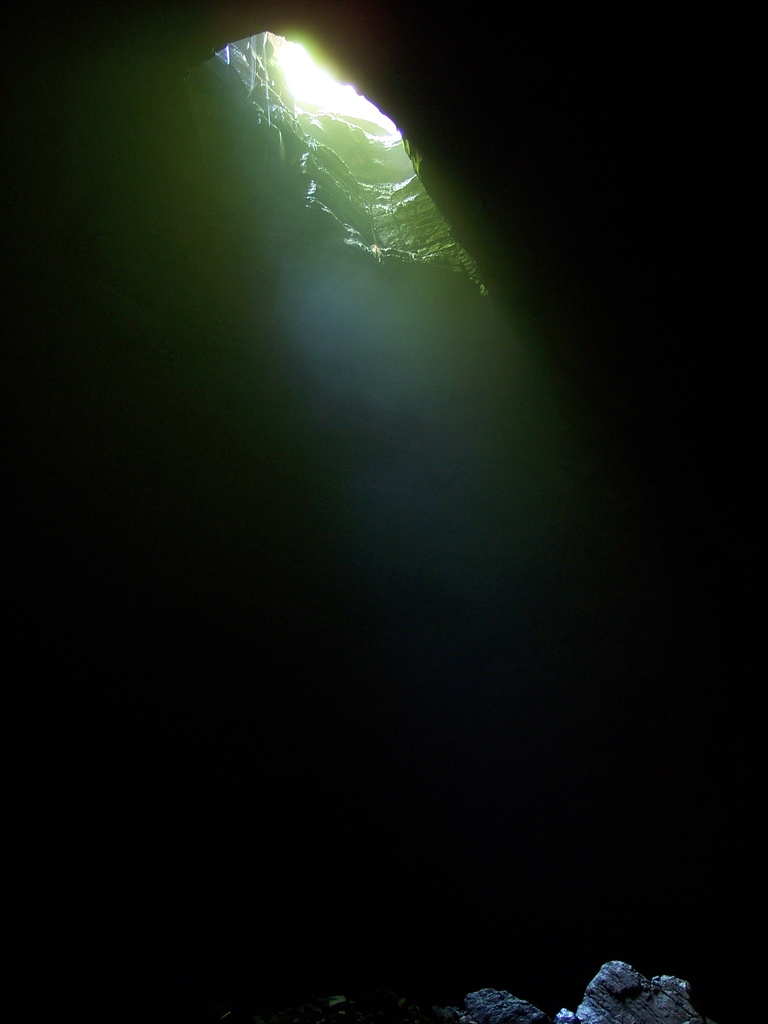
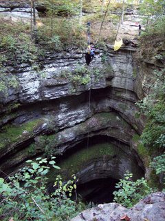
Beautiful view of Neversink Pit

We waited for a good rigging spot to open up, rigged to a tree and waited some more. Finally enough people were out of the way that we could rappel down with our rope. This pit is gorgeous. It's an open-air pit where the sun shines down in, the layered walls are covered with moss and ferns and small waterfalls. We were all able to get to the bottom before the sun set and were treated to an incredible view. This pit seemed tiny after doing Fantastic the day before! After Neversink, we headed to a nearby camping site, complete with bathrooms and hot showers.
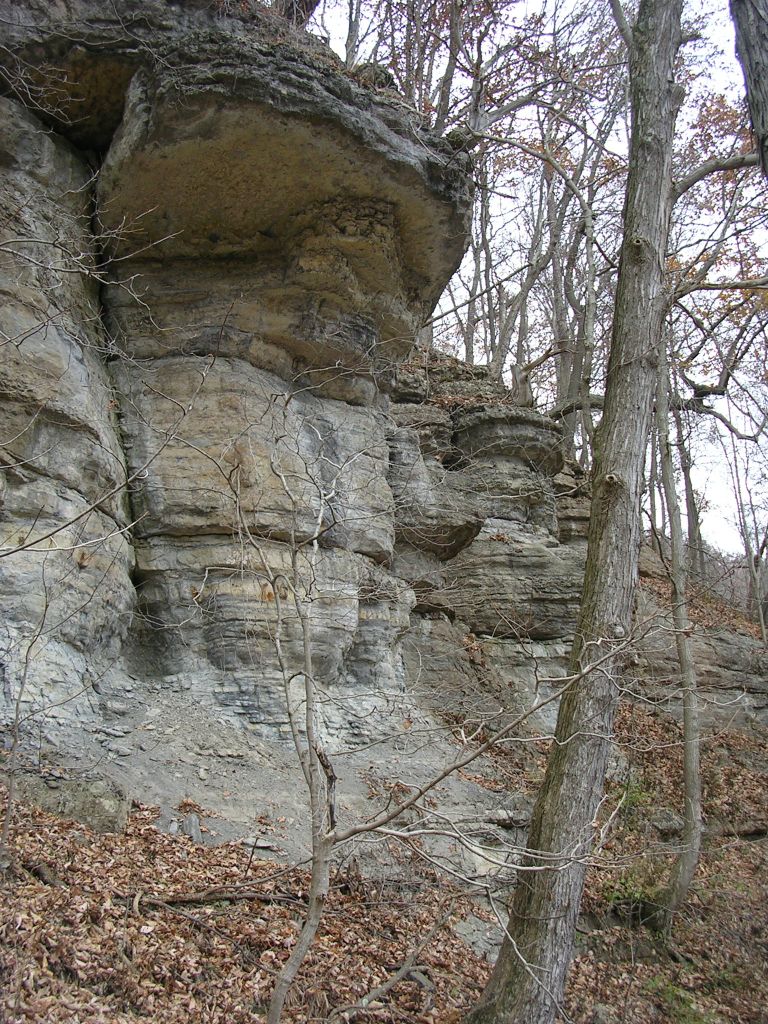
Day 3: Cagles Chasm

Sunday we opted to squeeze in one more pit before heading home; we drove to Tennessee for Cagles Chasm. We parked next to a kennel full of barking beagles and got geared up. Time for another hike up another hill, but at least this one was an easy one.


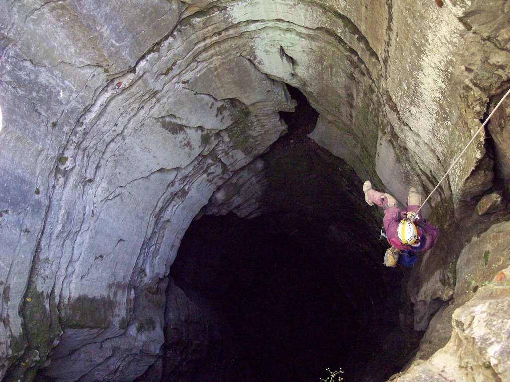
Mary Schmidt rapells into Cagles Chasm

Cagles Chasm is another open-air pit, a 186' vertical shaft which intersects a maze of cave passages on the way down. The view from the bottom looking up is spectacular, especially if you're a geology fan (you are, right?). With no traffic to contend with this time, we bounced the pit quickly and were ready for the drive back home by late afternoon.


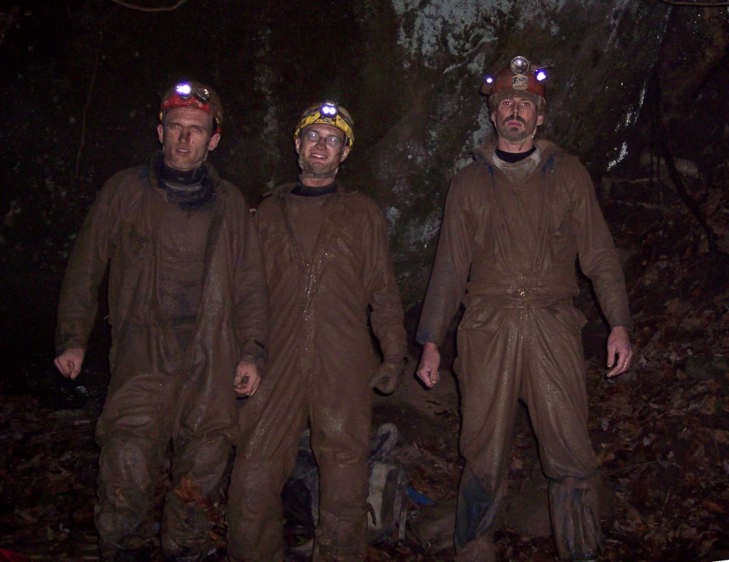
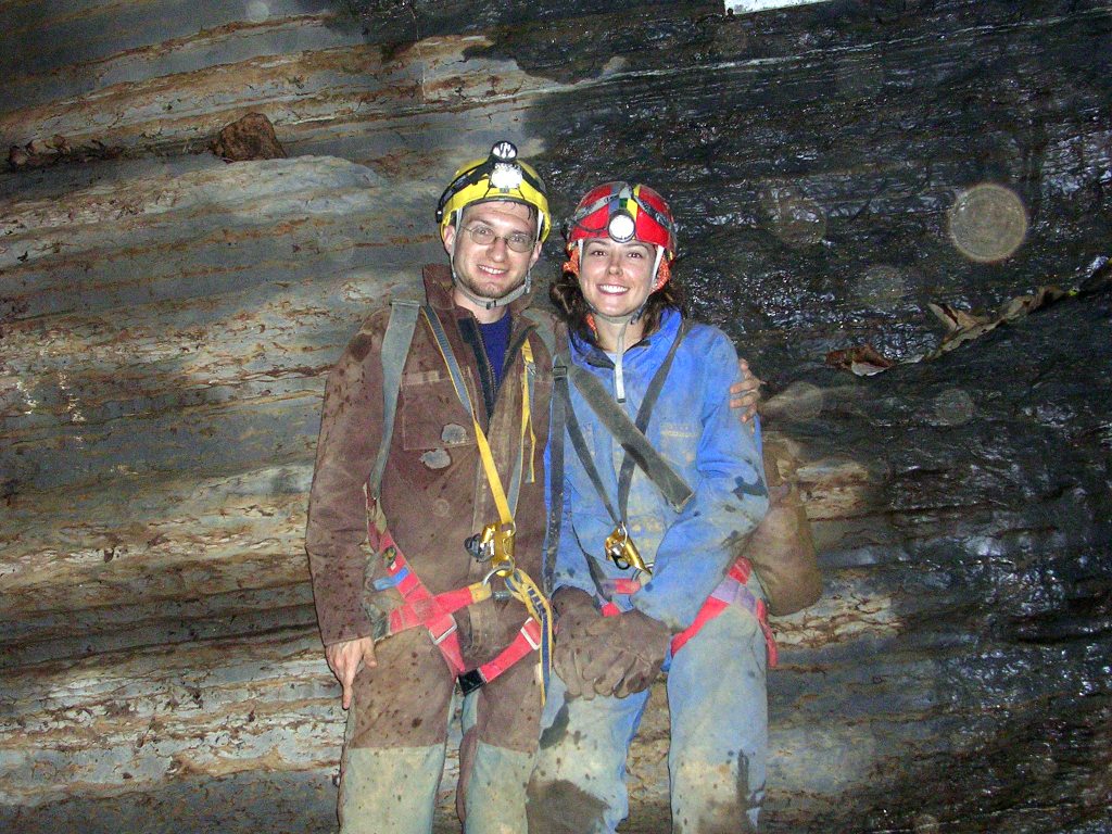
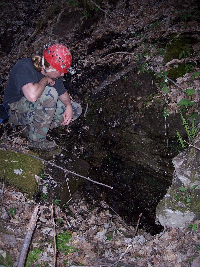
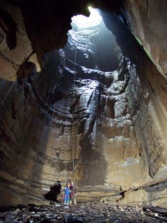
Judi and Dave at the bottom of Cagles Chasm

We made it back to Morgantown by 2am Sunday, after a great weekend full of amazing pits. Everyone was glad that we'd opted to skip the Cave-In to squeeze in more actual caving. After visiting these TAG classics, it's easy to see why this area is the best vertical caving in the country!

All photos by Brian Masney

See: Brian's trip photos
See: My trip photos

Wednesday, October 04, 2006

[trip] Geology Field Trip to Bowden

On Sunday October 1, Dr. Henry Rauch took our Karst Geology class on a field trip into Bowden Cave in Randolph County. We took the class in the main entrance, up the main trunk to the breakdown room, up into the shower room, then through the water course to the gate. It's amazing how many solutional features, structural and lithologic controls, and evidence of paleo-flow you find when you're actually looking for them.


2006 WVU Karst Geology class in the entrance of Bowden Cave. Photo by John Tudek

Saturday, September 30, 2006

NYDC Push Trip

Greg Springer, Brian Masney, Bob Griffith, and myself trekked into New Years Day Cave today with the intent of making the elusive Druid Cave connection.


Before...

We met at 9am and headed to the parking area at the rim of the Cheat Canyon. We hiked down the hill in the rain, geared up, and were in cave at 11:20am. Despite the rain, the cave's water level was still fairly low; we mostly stayed dry except for the rain-soaking we received outside. The outside temperature was roughly the same as underground, so the Druid winds were non-existant. After the rock-on-rock crawl - a 15'-long crawl with both chest and back against solid bedrock, roughly the half-way point of the current cave length - the group decided that we weren't feeling up to the torturous journey the the back of the cave. Rather than push past our collective limits, we aborted the mission and headed back out. I noted at least six crayfish on the way out of the cave, including one "lobster" about 5" from tail to claws. We exited the cave at 3:30pm, four hours underground, cleaned our gear in Lick Run and hiked back up and out of the canyon by about 5pm.


After.

Brian swears that next time we'll make the connection... (sound familiar?)

Choice quote from Bob Griffith: "This cave sucks. It sucks in more ways than one would think one cave could suck. It's a veritable smorgasbord of suckiness... But I've gotta see the Whack-A-Mole™ passage."

All photos by Brian Masney

Thursday, September 28, 2006

[trip] Beaverhole Upper

This Wednesday, the WVUSG took an evening trip into Beaverhole Upper Cave, located just over the Preston County line. Myself, Kyle McMillan, Brian Masney, and John Cunningham were there, along with three cavers new to the grotto, Rachael, Tom, and Aaron. We left the Rec Center at 6pm and headed down into the Cheat Canyon.


Brian, Kyle, Aaron, Dave, Tom, Rachael and John at the entrance to Beaverhole Upper.

The cave entrance was completely dry. I'd never noticed this before, but the cave stream actually sinks in the entrance room and resurges about 20' down the hill from the cave entrance; you can't tell that the water is being pirated at normal levels but we saw it sink right into the floor. We took the usual high route to the back of the cave, stopping to check out different nooks along the way. I poked around in some of the passage that usually moves water towards the back since it was so dry; we found a 4" crayfish stranded in a 6" puddle waiting for a good rain to wash him out.


John Cunningham defies gravity.

On the way out, a few of us followed the stream passage the whole way, then everyone met back up again. As I was exiting the front passages, I looked down behind a large rock and saw Rich Finley lying there in street clothes, grinning and waiting to jump out at someone! He, Cara Doud and Dave Olsen had popped in the cave just to say 'hi'. We all headed out, changed clothes and got back to Morgantown at 10:50, only to find that the new IHOP closes at 11pm. Damn. We were in cave for 2.5 hours.

Photos by Brian Masney

Sunday, September 24, 2006

[trip] Clover Hollow at Fall VAR

This past weekend was the 2006 Fall VAR, hosted by the VPI Cave Club in Glen Lyn VA. Judi led a trip into Pig Hole on Friday, but I didn't arrive until late Friday night. We didn't actually go to VAR itself until Saturday evening, and it rained the entire time we were there.

On Saturday morning, we took a trip into Clover Hollow, one of the classic Virginia caves. Ray Sira and Judi Wasilewski led the trip; also along were Alice and Brian from VPI, Rich and Eric from the Front Royal Grotto, Josh from BATS, and Terry from Raleigh NC.

The cave entrance is an oblong-shaped pit about 60' deep, and at the end of a small blind stream bed. Even though it rained intermittently, the main entrance didn't take any water while we were there. After rigging to a large tree at the lip of the pit, we rappelled into the entrance room, then headed down a hallway shaped drain corridor.


The Clover Hollow entrance pit as seen from below.

We did a short crawl and then came to a 3' wide straddle pit with about 15' exposure at the far end. It took a bit of people shuffling, but everyone made it across fine. There's a nuisance hand climb, then a short 20' nuisance rappel followed by another short rappel. We finally came to a big drop - around 90' - into some big passage with an audible waterflow below. Except for the drainage at the entrance of the cave and the bit of water falling near this big rappel, the cave was completely dry. We ditched our vertical gear and headed through some mazey anastomotic passages and a few climbdowns.

We eventually made it back to a dead-end room in some steeply-dipping passage called the library. This is where VPI stores all their top-secret training documents. I believe it also doubles in function as a time capsule for future civilizations to discover.


"I swear, I only go caving for the articles!"

After grabbing some lunch, we headed back out - taking a different route back. This way led us through the "mud river", a bone-dry crawl which is only about 12 inches tall and seems about 100' long while you're traveling it. We took a small detour to check out a passage loaded with formations and an amazingly-tall rimstone dam. Everyone ascended back up the big pit, up the nuisance climbs, and headed back out. We were in cave for about 5 hours.


Judi and I pose in the entrance room.

See my Clover Hollow photos.

Via Ferrata

After the WVUSG's beginners weekend, we climbed the via ferrata at Nelson Rocks WV. I've never rock climbed before (but I've got plenty of rappelling experience), and I was able to do the course easily. The entire course is bolted with steel rungs and steel cable. You have two lanyards attached to your harness so that when clipping into the next piece of protection, you always have at least one lanyard attached. You get some serious exposure and the views from up on the rock cliffs are absolutely breathtaking. In my opinion, it is easily worth the $35 fee to do the via at least once. Sadly, there was a fatality there the weekend after our visit - I believe the first major accident there ever.


Rich and Dave ascend the first wall of the via ferrata. We are carrying rappelling gear that we never actually got to use. (Photo: Jason Thomas)

See also my via ferrata photos.

[trip] Tucker County Survey

Brian Masney, Mary Schmidt and I went into our current Tucker County cave this weekend (2006-09-16) with the original intention of resuming the survey from where we left off last time - about 2.5 - 3 hours back into the cave. We were in cave around 10:30am, and the water level was the lowest I have ever seen it in the cave (which is also what I said last time).

We made it to the end of the main survey in 3 hours, 45 minutes, including two side-excursions to push tributary leads. Frustrated with the time and effort required to get back here, we decided to abort the survey trip and push forward to either find better passage or another entrance. The upper, main passage continues forward for a ways, and goes from walking passage to stooping passage to crawling on breakdown flakes. It primarily zig-zags following regular joint sets. At some point we dropped down the the middle level, but were kept up off the stream level the entire time. Travel became slow and painful through the breakdown flakes. We passed several right-hand side passages, though none looked very promising. Airflow was very weak and we were not having fun.

We eventually came to another right-hand side lead, this one very curiously keyhole shaped, while the "main passage" continued as a nasty breakdown crawl. Both appeared to be virgin passage - we chose the keyhole. This passage went for 30' or so, then got wider and more rectangular with one or two small, meandering, phreatic tubes in its side. We found a window in the floor, for the first time in several hundred feet revealing water to us again. Excitedly, I rushed on to find a way down, scurried down a nice chute, and shouted back up "we've got cave!" This interesting passage has almost vertical walls, about 3' wide, and almost completely parallel, making it look like an aqueduct (at least, it would have had the cave not been so dry - it was more of a mudduct). The passage had faint airflow. Mary took the lead and scooped about 150' - 200' of walking passage which kept getting larger and eventually taking on a meandering shape. Deciding that we needed something to coax us back into this cave again, we turned around in nice walking passage. We had travelled at least 500 (unpleasant) feet from the current survey.

We were out of the cave at 7:45pm, stopped by Kevin's house to check in, and then had pizza at CJ's.

Wednesday, September 06, 2006

[trip] Simmons-Mingo at OTR

On Saturday of the 2006 OTR, Judi Wasilewski, Llew Williams, Brian Masney, Bob Griffith, Mary Davis, Garth Dixon, and myself (Dave Riggs) took a trip into the historic entrance of Simmons-Mingo Cave. Most of us had been to this entrance of the cave less than two months ago but had been stopped by a wet stream crawl. Our intention this time was to bypass the stream crawl by rappelling a ledge that bypasses it.

We met at 11am at the Monongahela Grotto's tent. We very carefully 4-wheeled out of the muddy OTR campsite and caravanned to Mingo Flats. Llew bribed the landowner's mean-looking dog with a granola bar, and he instantly became Llew's best friend. As we were almost completely geared-up, the Cleveland Grotto showed up behind us; they planned on taking a horizontal trip into the PSC passage. Even though there had been very significant rain the last several days, the stream at the parking area was low and sunk into its sediment bed, and the spring at the cave entrance was dry.

Llew and dog

The way to a mean dog's heart is apparently through his stomach. Llew with his new best friend.

Our team descended the entrance climb, aided by the existing handline. We headed down, down, down the mountains of breakdown, taking a quick detour to peer into a really deep pit on the right. Continuing down, down, down the breakdown, we spotted the Cleveland team on the breakdown mountain above us coming down like a line of christmas lights, which was a cool sight. They followed us to the start of the PSC passage, and Llew gave them directions from there. We eventually made it down to The Etrier room.

This is a 12' overhung ledge rigged with an old webbing etrier which leads down to a mid-level room. The mid-level room goes to a small, wet, stream crawl on the left, and a 30' ledge to a lower room on the right. We decided to rig a rope above the etrier, down the drop, around the corner, and down the ledge. This turned out to be a bad idea due to the large number of rub points involved. Next time, we'll either get wet in the stream crawl, or we'll rig the pit to the right just before the etrier drop (which looks like it connects to the later stream passage).

Anyway, everyone descended the two drops, ditched our vert gear, and headed down a passage towards the stream. It's here that Simmons-Mingo Cave really starts. The stream passage moves a lot of water and has carved a giant canyon passage. The floor is filled with potholes that make it look like swiss cheese. We climbed down into the canyon passage and headed upstream since it looked like we'd stay dryer than going downstream. Though the water didn't seem very high, we all got wet before long. After touring the upstream branch and poking leads, we decided to head back.

Bob and Mary in canyon

Bob and Mary in the big canyon passage. The cave stream is about 10' below them.

One-by-one we ascended up the first ledge. Progress was slow as several people were working out kinks in their frog systems. I was the last one up, pulled and stuffed the rope, then realized that my pack was sitting back down at the bottom. Damn. Rather than make everyone wait on me to rappel and ascend back up, I opted to try out the stream crawl instead. As I'd heard, it was definitely a wet crawl, with my chest in the water and butt against the ceiling. It's obvious by the size of the cobbles in this stream that it moves a good bit of water. We'll need to bring spare dry clothes if we take this route next time.

After derigging the rope, the climb back up and out all that breakdown began. This was pretty tiring work while wet, muddy, and carrying rope and vert gear. Brian took some good photos in one of the big rooms on the way out, then he sacrificed one of his flash units to the cave gods. We were back outside after about 6 hours, and the Cleveland Grotto had already left. We packed up and stopped for dinner on the way back to the campsite.

Group photo

Group at the historic entrance to Simmons-Mingo Cave. (L-R) Brian Masney, Dave Riggs, Judi Wasilewski, Bob Griffith, Mary Davis, Llew Williams, Garth Dixon

All photos by Brian Masney

OTR 2006


The 2006 Old Timers Reunion has come and gone; the rain seemed to scare away some of the kooks making it pretty enjoyable. Unfortunately, the rain also made it cold, wet, and incredibly muddy... but you'll have that. Judi and I did some truck camping to avoid sleeping in a nasty tent, but we still wound up leaving at around midnight on Saturday to head back to warmer and dryer quarters.

Highlights:

- Instructions at the gate on the way in: "Do something weird."
- Caving trip into the historic entrance of Simmons-Mingo Cave
- Bill Biggers told me that I look just like Lew Bicking
- I picked up the Northern Pocahontas WVaSS Bulletin, the Karst Hydrology Atlas of WV, and the '89 SERA Guidebook
- Being videotaped for the blockbuster new film, How I Learned to Stop Worrying and Love Druid Cave
- Seeing lots of friends and meeting lots of new ones

Monday, August 14, 2006

[trip] New River Cave BSA Trip

Judi Wasilewski and Pete Sauvigne of the VPI Cave Club and myself, Dave Riggs, led Boy Scout troop 140 of South Carolina into New River Cave this weekend. Our group consisted of 18 scouts, four adults and the three guides.


Troop 140 along the road below New River Cave

New River Cave is the longest cave in Giles County, VA, at over 5 miles in length. Access to the cave is forbidden without written permission from the owner, Tim Kilby. Parking is along the New River, and the sole cave entrance is up an extremely steep hillside. We slowly climbed up to the entrance, did a final equipment check, and all met in the entrance room just inside the cave. The land-owner had prepared a nice written statement to introduce everyone to the cave and to caving.

We broke the large group up into three smaller groups of 6 scouts each. My group, age group 15 - 18, spent about 3 hours in the cave. We headed back in to the register room, through lots of decorated passage, and back to a big fault chamber with a steep dirt slide down the fissure. They had a great time, asked lots of questions, and did an excellent job of traversing the cave terrain. Upon exiting the cave and realizing that we were the first ones out, they were eager to head back in and explore the cave aimlessly (and to try their best at surprising the other groups)!

The last group made it out after about 4 hours in cave, and everyone headed back down the mountainside to eat sandwiches. The scouts and the trip leaders both had a good time on this trip, and I'd enjoy leading another BSA troop in-cave again.

Monday, August 07, 2006

[trip] GVKS Survey 2

Another survey trip for the GVKS again last week, this one 16 hours with zero feet surveyed!

Terry McClanathan and I ascended the Southwest Dome, currently the tallest known pit in WV, to get an accurate measurement of its height. There's a rebelay about 185' off the floor; it's at a small loft so you can get off rope onto your feet when you cross the rebelay. The loft is large enough for a couple people to stand and keep clear of rockfall from above. You pendulum about 10' to the left and continue upwards, the top of the dome slowly getting narrower and narrower to the point that there's a nice "helmet check" shelf to avoid near the top.

The very top of the dome is really just a mud-floored shelf; another pit is visible to the left, and there's no obvious passage from there, though I never unclipped from the safety line to check. There were several small solutional passages intersecting the pit on opposite wall on the way up, but no water was noted from below the rebelay to the top of the dome.

The rebelay pendulum was a bit tricky on the way down, but from there you've got a straight rappel down the rest of the pit - at least, you would if the rope weren't so muddy. I had to feed my microrack most of the way down because it was so gritty! The last 75' of rope seemed clean, presumably from the small amount of spray present (we did not get wet on rope). The pit measured 247' from bolt to floor, 240' from the upper ledge.

It was amazing to follow the bolt route up this huge dome, what an incredible effort it must have been!


Frogging up the tallest known dome in WV... 20' off the floor, only 220' left to go!

This cave is NOT open to the general caving public. It is only open for survey by the Germany Valley Karst Survey under contract to Greer Industries. OTHER CAVING IS STRICTLY FORBIDDEN.

Photos by Brian Masney

Wednesday, August 02, 2006

Misc.

Judi and I drove down to Mingo Flats/Elk River Valley and met Llew Williams, Bob & Mary, and a few others for a trip into the historic entrance of Simmons-Mingo Cave. Llew had his camp set up in the mouth of the cave to keep cool. We climbed down and down a few breakdown hills, then descended a cable ladder to a nice pit and a wet crawl. Nobody had on vert gear, and the majority voted against getting wet, so we never made it to the Good Stuff.

One of my New Years Day Cave trip reports was published in this month's West Virginia Caver, does this make me a BNC?

Hellhole is now the 16th longest cave in the US at 23.90 miles. (Edit: 2006 season closed with 24.92 miles, passing Sloans Valley for 15th place!)

I got my TRA membership in the mail today... not bad considering I mailed it in the day before the deadline. See you at OTR!


Judi Wasilewski and Dave Riggs in Simmons-Mingo Cave. Photo by Llew Williams.

Thursday, July 13, 2006

[trip] Barton Cave Beginner Trip

Doug McCarty, Brian Masney, John Tudek, John ?, and myself met at the Exxon on route 857 at 6pm for a beginner's trip into Barton Cave. We waited for half an hour, but the beginners never showed. We drove to the cave, geared up, and headed in. The cave takes about 45 minutes to get to from Morgantown, and is a 10 minute hike from the parking area. It's a very easy cave, horizontal, not too crawly, and mostly dry. It's formed in very sandy limestone or limey sandstone. We were back in Morgantown in time to get Mexican for dinner.

Sunday, July 09, 2006

[trip] GVKS Survey

This weekend I managed to get on a GVKS survey team into a legendary closed cave. Brian Masney and I were on a survey team with Dwight Livingston; we were to find and survey a lead off a particular large room. We rigged and dropped the beautiful entrance drop around noon on Saturday and traveled about 4.5 hours into the cave, doing three more rappels on the way. Parts of the cave felt like going on a hike in the mountains, climbing steep hills or walking rocky trails in wide-open, massive passage. Of course, there were also plenty of squeezes and crawls, which were just as nasty as the borehole was spectacular. We spent a few hours investigating every lead we could find in the area, but couldn't find any that had not yet been surveyed. At least Brian got some awesome photos of the area. The trip out was exhausting but still enjoyable. We were above-ground at 1:30am.

entrance pit

Beautiful view of the entrance pit

brian in large passage

Brian Masney models his new boots in some big passage south of the large room

dave in large room

Dave Riggs and shadow in another large room south of the large room

Photos by Brian Masney.

Monday, June 12, 2006

[trip] Biology Study

Bob Griffith and I helped Dr. Daniel Fong and Dr. Horton Hobbs on a biology study this week, cataloguing invertebrate cave fauna. We took them to Beaverhole Upper, Maiden Run #2, and Maiden Run #1 on Monday, then to Beaverhole Lower on Tuesday. I'm now an honorary vertical biologist.


Horton Hobbs, Katie Schneider, Dan Fong, Dave Riggs

[trip] New Years Day Cave Survey

Aaron Bird, Brian Masney, Jason Thomas, and myself (Dave Riggs) made another trip back into New Years Day Cave this weekend (June 10). We first surveyed from the bedrock-on-bedrock crawl, through the Whack-A-Mole™ Way, to the last dig. We then broke up into two teams, and together surveyed through Jason's wormhole, past the dome, past the low/wide stuff, and into the crumbly canyon passage that we last turned around in.

We were in cave about 9 hours and surveyed about 1010', which brings New Years Day Cave to a whopping 2499' length - now the longest cave in Monongalia County (topping Maiden Run Cave #1 at 1800')!


Amazingly, we do this for fun.


The line plot shows NYDC heading directly for the end of Druid Cave, with about 400' straight-line distance between their surveys. We turned around in canyon passage that requires a hammer to continue forward, and the Druid wind is still very strong in this far end of the cave.

Photo by Brian Masney

Saturday, June 03, 2006

Hiking Maiden Run

I went for a nice hike along Maiden Run this afternoon. I took some photos of Maiden Run #2, Maiden Run #1, a FRO above Maiden Run #1, and a small opening that may be Maiden Run #3 (see better photo from last visit). I also tried to find a sinkhole that the Mon Grotto dug in 1975 (see email discussion), but didn't have any luck.


Entrance to Maiden Run #2 is a down-sloping crawl to stooping passage with a cave stream. This cave lightly blows cool air.

Thursday, June 01, 2006

[trip] Caving in Tennessee

We had a large turnout at TAG this past weekend: Rich Finley, Jill Pile, Jason Thomas, Melissa Parker, Dave Riggs, Judi Wasilewski, Bob Griffith, Mary Davis (both showed up on Monday), Ryan Ellers, Garth Dixon and myself (Brian Masney).

We camped in Fall Creek Falls State Park in Central Tennessee on Friday, Saturday and Sunday nights.

On Saturday, we went into Rumbling Falls Cave. We split into two teams: Jason, Brian, Dave and Judi comprised the first team that went in to get everything rigged. Later in the day, the derigging team (Rich, Garth and Ryan) came into the cave. Rumbling Falls has a 70' entrance drop. You continue upstream through walking passage. There are two 20' up climbs along the way. You continue upstream and the passage eventually becomes a hands and knees crawl and then it becomes a belly crawl in the stream. At this point, I thought: "Why did we come here? We have this kind of stuff back home in Morgantown!" It eventually opens up a little bit and it requires several climbs, crawls, chimneys, cussing, etc. to continue through the passage. You eventually cross a drainage divide. At this point, the passage slowly starts to get a little bigger. You walk a short distance and you come to the Rumble Room. It is 5 acres in size and there is a 201' rappel to the top of the breakdown. This is the biggest known underground room in TN and it is big enough to fit the Lousiana Superdome in there.


Judi at the top of the Rumble Room.


The 5 acre Rumble Room in Rumbling Falls Cave. Thanks to Jason Thomas and Dave Riggs for helping light up the room with their Sten Lights while I did a time exposure with my camera.

On Sunday, everyone went to Conley Hole. The cave is about 9/10 of a mile from the parking area. The first half mile is easy walking through a field. The rest of the hike requires bush whacking through the woods to find the cave. There isn't a trail to the cave. Luckily I had good GPS coordinates to the pit or else we wouldn't have found it. The entrance to the pit is 20' in diameter and it really opens up about 50' from the top. The pit is about 186' deep.


Judi at the entrance to Conley Hole. Photo by Dave Riggs.


The entrance to Conley Hole from the bottom. Notice the rappeller on rope.


Ryan and Dave standing under some formations in Conley Hole.

On Monday, everyone went to Mystery Falls Cave. This pit is 286' deep and it is the deepest known pit in Tennessee. The cave is gated and it requires a permit to visit the cave. There is about 100'+ of horizontal passage that leads you to the top of the 286' pit. The pit is highly decorated and it really bells as you get closer to the bottom.


Dave at the top of the 286' drop in Mystery Falls Cave.


Mary at the bottom of the 286' drop in Mystery Falls Cave.

All in all, the entire trip went really well. We had too many people in the pits though. This made some of the trips really long. Next time, we need to split up into smaller groups.

I uploaded photos from the trip to my Flickr account. Special thanks to everyone who helped out with the photos. See also Dave's photos from Conley Hole.

Photos by Brian Masney unless otherwise noted.

Wednesday, May 17, 2006

[trip] New Years Day Cave Push

This past Saturday, May 13, Brian Masney, Jason Thomas, Bob Kirk, and myself (Dave Riggs) made another trek into New Years Day Cave. NYDC is believed to be the still-unconnected upstream trunk of Druid Cave. The goal of this push trip was to get past a boulder blocking further progress into the cave - Bob had helped us past similar obstacles at the downstream dig, and was making his first trip into NYDC to help us continue forward.

We met in Morgantown around 9am, drove up to the lip of the Cheat Canyon, and started the trek downhill. All four of us suited up in wetsuits with warm layers over top, carried spare layers sealed up in dry packs, and packed in hand warmers, candles, and a heat tent. Armed for battle with a brutal cave, we headed underground at just after 10:30am.


Brian Masney, Dave Riggs, Jason Thomas, Bob Kirk prepare for another relaxing day in New Years Day Cave

Luck seemed to be with us; the water level was low and the moderate temperature outside meant that the cave air was relatively still. Because we were able to stay dry, we actually had to stop and cool off halfway through the sandy "beach" crawl - a wide silt stream bank with a very low ceiling. Everyone was soon soaked after trekking through the cave stream and going headfirst down into a much-loathed water crawl. From here, we did a short jog through the Mon County Borehole and made it to the rock-on-rock-slab crawl at the end of the current survey.

We went ahead and to the Whack-A-Mole™ passage, so named because the finger-like protruding shelves needed whacked with a hammer to comfortably walk through. This was my first time past the last survey station, and I was honestly impressed with the size, the speed we were able to travel, and the distance that this passage covers. For New Years Day Cave, being able to stand upright and walk forward for more than a hundred feet is a welcome treat. I expect the next survey trip to add a good bit of distance because of this passage. Notable here was a large number of shell fossils embedded in several of the limestone beds along the walls.

Finally, after close to two hours(?), we reached our destination: a narrow trench going down from an upper passage to the stream level below, blocked at the very bottom by a boulder just barely larger than the opening it guarded. Jason, Bob, and I started to work on it immediately. Jason and I each drilled a hole, but progress was slow. The passage was apparently blocked with the only sandstone boulder in the entire limestone cave - it would quickly crumble and fill any hole we drilled, while the edges would crumble under the pressure. Meanwhile, Brian suited up, grabbed a shovel, and pushed a parallel lower path in the stream. He made it forward almost to where our boulder was, but was obstructed by more breakdown.

After unsuccessfully trying to tug the boulder out of the way with webbing, it was decided that our best bet against the unwilling rock was to simply pulverize it with the hammer. We easily rounded all the corners, but it was extremely difficult to swing powerful blows in the bottom of the 18" wide slot - progress was again slow. In addition, we were very weary of some sketchy breakdown seemingly balanced on the rocks adjacent to our sandstone foe. We took turns pounding on it, gradually chipping it smaller and smaller, and keeping us from becoming too chilled.

Near 4:30pm we succeeded in rolling the deflated boulder out of the way, leaving a huge mound of powdered rock behind in its place. I squeezed through the opening, being careful not to touch the breakdown on my side, and crawled forward in the stream passage. I shouted back, "It goes... but it sucks!". I went about a body length in and could see that the tunnel shrunk up ahead to painful proportions, with no visible place to turn around. Worse still was the backside view of the sketchy breakdown... the protruding bottom rock itself appeared to be held in place just by the weight of the piles of rock above it. I squirmed out and Jason popped in to confirm that this was at best an obstacle to tackle another day, and given how unstable the adjacent wall seemed, could at worst be the end of the line for New Years Day Cave.

Everyone huddled up above to discuss the situation. Frustrated that this nasty cave could defeat us after all the trips in and out over the past two years, Jason decided to prove to NYDC who was in charge. He went head-first into the sketchy upper "passage", a pile of breakdown supported by breakdown with a roof made of... breakdown. He started pushing and shoving rocks aside, and inching his way forward - head-first, downhill, without room to turn himself around. And after at least 15 grueling minutes of this...


Jason Thomas triumphs over NYDC


...Jason had broken into a virgin room.

We clamored one after one through his wormhole, each of us prying or tossing aside a rock or three so we could fit. The room is about a dozen feet tall, one side frighteningly walled by a mudslide. You drop down to stream level, follow the stream forward a bit and the ceiling becomes lower, to stoop height. A dome, 15 - 20' high awaits, with the first real formation I've seen in New Years Day Cave. From here the stream meanders a bit, the ceiling gets lower and lower, the passage gets very very wide - probably 40' at its widest width, 2.5' at its lowest height.

A couple-hundred feet in, there is a boulder intersection, which we went around and followed the wind down a crawl. Here the passage becomes very different - fingery canyon passage, narrow but 6 - 8' tall, meandering with the water. The "limestone" has a black coating and the fingers can be easily broken off, as if composed of some rotten mud-rock. The Druid winds continued, but we turned back to save the booty for another survey trip.


Jason in the virgin canyon passage, note the rotten limestone walls

The trip back out was exhausting. The pointed shelves in the Whack-A-Mole™ passage are shaped such that they poke and grab at every piece of your suit and pack on the way out. We were all coated with sandy mud, and our packs were filled with gear (Bob measured his with a fishing scale afterwards - 50lbs). We finally exited, before dark, scrubbed ourselves off in Lick Run, then hiked back up the brutal hill with mixed emotions. Brian summed everyone's feelings up by saying "Jason, I don't know whether to hug you or kick you!"

Photos by Brian Masney

Tuesday, May 02, 2006

2006 Spring VAR

This is not a trip report! Brian and I drove down to VAR in Grottoes VA this weekend. They went into Grand Caverns, I didn't. We went to the Devil's Marble Yard in the Jefferson National Forest, which was awesome. I picked up an original printing of WVaSS Bulletin 5, Caves of North Central West Virginia from Speleobooks. On the way home, Brian and I hiked to the top of Seneca Rocks.


Brian Masney, Carrie Blankenship, Sam ???, John Tudek, Judi Wasilewski, Dave Riggs at the Devil's Marble Yard

See Brian's photos for more of a trip report than this posting is.

Friday, April 28, 2006

[trip] Ridge Walking Rt. 7 Part 2

Brian, Jason, and I did some poking around Rt. 7 this evening. We checked out the entrance to Maiden Run #1, found the entrance to Maiden Run #2, and checked out a resurgance and FRO between the two. Both Maiden Run #1 and #2 were blowing cool air.

We then drove down the road a bit and found Nuttinbuttawett Pit, a 20' deep crevice that completely swallows a small stream. The water resurges a few dozen yards down the hill, and looks like it might drop underground again on one side. This area is also peppered with springs and lots of weathered limestone outcrops.


Jason Thomas checks out an interesting karst feature between Maiden Run #1 and #2


Me descending Mon County's deepest pit by hand, Nuttinbuttawett Pit

All photos by Brian Masney