Showing posts with label germany valley. Show all posts

Saturday, January 31, 2009

[trip] Shovel Eater UpDog Survey

This past weekend was my return to Germany Valley after a 6 month hiatus; while our lead quickly died and we surveyed just under 90 feet, I was treated to a relaxing tour of several "new" parts of Shovel Eater Cave. Brian Masney and I drove from Morgantown on Saturday morning and met up with John Harman at his house, then grabbed a late breakfast - or rather, early lunch - at The Gateway. We stopped by the landowners' farm for permission to head in to Shovel Eater as well as to do some "landowner relations"; Brian presented them with a stack of glossy cave porn: some fantastic SEC photos that really impressed the family, the first that they'd seen of their cave.

After a lazy start, we managed to get underground at somewhere around 12:45. The trip in was uneventful; we stopped to snap a few photos for Brian and then dropped down the Ohio Bypass, which had only a trickle of water. At the HHA junction, we turned right and continued up the main passage until we ducked under a relict-flowstone shelf and rappelled a small pit with crumbly mud walls and some water raining down from the ceiling. From this point, the passages became a series of sinuous, tall, narrow canyon, where we continued to travel upstream and climbed up several of John Harman's bolt climbs to higher and higher levels, reaching the EFN survey, which had stopped at a 20 foot pit in the floor and a bolt traverse around the perimeter...


Dave rappelling the Y-hang above the Ohio Bypass in Shovel Eater Cave. Photo by Brian Masney.

We finally began to survey, and as Brian snapped open a cyalume stick to use as a station light, it exploded, spraying his face and eyes with glow-in-the-dark chemical goo. Thankfully, he was able to stay calm and collected while standing blind, eyes burning at the top of a 20 foot pit; I did my best to flush his eyes out with an entire liter of water, and being the trooper that he is, he was then ready to shoot instruments. It was then that we noticed that this area of the cave has a jaw-dropping assortment of updog on the floors, walls, and ceiling, and it was obvious to us that this should be called the UDS, or "UpDog" Survey. Never before have I seen so much updog in one place!

Our survey shot across and over the pit, to a mud-and-breakdown slope which fed into a doubled-back canyon passage beyond. John had previously placed several bolts, and he rigged a traverse line to safely cross. The passage headed up to a wider canyon spot at mid-level, and up another 15 feet to the original phreatic tube in the ceiling. Sadly, this tube ended within 5 stations, choked with cemented mud and sandstone cobbles in the upstream direction, sealed by flowstone downstream. Unseen holes in the floor dropped rocks and mud balls down to the go-nowhere EFN canyon below. Without fanfare, our lead died, so we packed up and headed out. John derigged the traverse line and the two bolt climbs on the way back to HHA, which should be a big disappointment to all the "twenty footer" hounds.


The "sunnyside up egg"; a formation along the EFN canyon. Photo by Brian Masney.

After grabbing a bite to eat, we set off for some sight-seeing. We continued up the HHA trunk, ducked underneath the WVU bolt climb, and visited the Echo Dome(?) at end of the passage. I hit this beautiful dome with my disto and measured 101.4 feet to the top. We backtracked to see an area called Pristine, where John spied a potential bolt climb that he plans to do ASAP. Eventually, we made our way down to HHH so that Brian could meditate at the foot of the omnipresent "Buddha" in the Acoustic Persistence Chamber.

Eventually, we decided that we'd poked around long enough, and headed out of the cave. Again, the trip was uneventful, and we were on the surface by 1:30AM, with around 12.5 hours underground.

Saturday, July 12, 2008

[trip] Return to SEC's Rushin' Rift

This GVKS weekend (2008-07-12), Nikki Green and I did a two-person "squeezefreak" trip to survey the upper passage at the top of the Rushin' Rift in Shovel Eater Cave. We were one of the last teams in cave, at around 10AM, and hit the tail-end of rope traffic in the entrance series of the cave. At HHA15 we picked up a 9mm rope, left a note for Mark Minton and Yvonne Droms (as a safety precaution for our two-person survey), and headed for the nearby Rushin' Rift. We found Bob Zimmerman's team before we found the Rift, and they stuck Nikki down two tiny leads which didn't go. They claimed to have checked out the Rift on the way in, and found it to be silent; we confirmed this ourselves, no sign at all of "The Devil's machinery", so apparently the water within this chasm is intermittent.

I rigged the 50 foot drop, though we did not rappel into it - rather we used the Y-hang as aid to go straight back into the upper rift passage. We shuffled back to the unlabeled calcite chunk cairn (CN1) which marked the end of the previous survey, located just before this passage goes from "small" to "tiny". Before we could mark our first station, the hungry rift ate our only roll of flagging tape; thus, all stations on this survey are marked with blue sharpie on rock.

This upper rift passage is capped by a fault plane, dipping about 20 degrees in a generally East direction, which frequently appears as a smoothly-sculpted calcite vein in the ceiling, and sometimes as oddly-shaped phreatic proto-passage formed within once-fractured rock. Freshly-broken crystal gives off a sulfur smell. An extremely narrow canyon is incised into the floor, usually too narrow to eat a body, but almost always the perfect size to eat the conveniently-placed foot or survey tape. At several places - notably near our first station and past our last station - rocks dropped down this canyon can be heard to tumble down quite an impressive distance, what I would estimate to be at or beyond 50 feet, though "tumbling rock" can be deceiving. At one point, we clearly heard hammering, which we later discovered to be the work of Bob Z's team. Airflow was never more than "slight", if that. Paleoflow direction is likely in the direction of our survey - away from the cave's main passage, and generally Northeast - at least in the upper rift.


Representative sketch of the upper Rushin' Rift - tiny passage with a nasty canyon incised into the floor.

We surveyed the entirety of what I "scooped" on the previous trip. I had estimated this to be on the order of 200 feet, but the miserable nature of the passage caused me to overestimate by 2X. At the end, the passage turns down the dip of the fault plane, losing around 15 feet of elevation, where the still-hungry rift devoured Nikki's digital camera (sorry, Nikki!). Finally a "room" is reached, which is comfortable enough for two people to stand and eat lunch; rocks dropped down here tumble down what sounds like a terrifyingly-deep chasm, an experiment that I repeated many times in the name of science. Beyond, the passage becomes too tight to follow, but the deep canyon may be accessible just beyond our last station, as the canyon widens in a sharp meander. Upon finishing, we de-rigged the unused rope and returned it to HHA15.

We surveyed 115 feet in a painful 10 shots. I do not consider the upper Rift lead to be killed yet. Rather, I believe that the only way to further explore the Rushin' Rift is to ignore the too-too-tight lower rift passage, and to rig rope from the top passage and enter the rift from one of these upper access points.

Saturday, March 08, 2008

[trip] Shovel Eater Cave - Rushin' Rift

After heading down to Germany Valley late Friday night, through some of the thickest fog I've ever driven in, finding the field house dark and quiet upon arriving at 1:30AM, and getting a good night's sleep in my hammock underneath a torrential downpour, I met up with a large group of GVKS folks at The Gateway at 8AM Saturday morning. I was put on Bob Alderson's team with John Harman and Cullen Hencke, and our goal was to investigate a fascinating lead off of HHA, which was dubbed the Rushin' Rift upon its discovery on October 27, 2007. Mark Minton described it as:

Under one wall the canyon dropped down a deep, narrow pit which we named Rushin' Rift. A strange humming sound could be heard in the distance, unlike anything we had heard in a cave before. Air? Water? The Devil's machinery?


We arrived at the SEC entrance around 10:15AM and headed into the entrance series. After the third rappel, we ducked down under the water to a drippy, muddy room containing the new "Buckeye Bypass" (as we decided to call it). A short, uncomfortable, diagonal rappel to a rebelay drops you down to a series of traverses in a passage that looked vaguely familiar to me... the bypass seemingly teleports one all the way down and past Harper Canyon - wow! We were to HHA in no time at all, and were staring down into a complex intersection of narrow canyon passages off to the side of the "main" passage. Sure enough, when everyone was quiet, we could hear "The Devil's machinery" from the deep slot.

John and Bob cleaned the rock surface and set three bolts; a single bolt at the top for a traverse line down under the "lip" of the canyon, with two bolts for a free-hanging "Y" rig. We later taped this drop at 49.1 feet from the upper bolt. The rappel down is tight, with shoulders against the wall for most of the way, and should not be done while wearing a pack (oops!).

The lower canyon has a flat floor, is seldomly wider than 24 inches, and doesn't offer many (er, any?) opportunities to stand up. It is dry, with no sign of even a past stream, and with highly abrasive popcorn lining the walls and obscuring paleo-flow evidence. Upstream goes only 10 feet to a formation-obscured hole in the floor which was just a couple feet deep. Downstream the canyon twists in very tight meanders and appears to loop back on itself; when Bob pushed downstream I could hear him closely from the upstream hole. With extreme effort, Bob pushed downstream and had much difficulty returning. I followed and tried to "shave" popcorn from some of the squeezes for him to get back through. I did not attempt to push as far as he did, but I would guess that neither of us pushed farther than 40 feet from the rope.

In the lower canyon, we could definitely hear "The Devil's machinery", which sounded distinctly like a waterfall. I personally didn't think that it sounded louder after pushing in the downstream direction, but others in the party stated that they did. Having no luck pushing this tight, lower canyon, we decided instead to investigate the upper levels of the canyon. While Bob and I taped the drop, John and Cullen headed up and scouted it out.

The upper canyon, which is reached by traversing down to the Y-hang and going behind it, consists of an oval-shaped phreatic tube with a narrow canyon incised in its floor. It is bounded from above by a low-angle fault or fracture, which has been filled in with a band of calcite crystal. This calcite band has been solutionally sculpted in places to reveal a beautiful, "organic"-looking, flowing crystal ceiling. The upper passage follows the strike of this fault plane. It is very dry, showing small bits of gypsum in places, and is more comfortable to move in than the lower passage, though it is still relatively small passage. We were still able to hear the sound of water, off far in the distance somewhere but didn't seem to be any closer to it.

While Bob, John, and Cullen surveyed out of the upper canyon (from a point where the ceiling became quite low, marked by a cairn of calcite crystal), which yielded only around 50 feet of easy survey, I pushed in the upstream(?) direction, which seemed to correspond to what appeared to be downstream in the lower canyon. Confused yet? I pushed forward through alternating low-and-tight to narrow-and-tight to just-plain-tight tube with canyon or just canyon without floor (no actual exposure however), for what was probably 250 feet. At times I felt faint airflow coming up from the lower canyon, but it was never "blowing", even though I was in relatively constricted passage. After thoroughly shredding my cave suit on the dry, rough passage, it seemed to head down dip of the fault plane, going downhill (though I still believe upstream direction) approximately 10 feet. At this point, I could not hear the others, nor could I hear the sound of water at all. The passage isn't suitable for large cavers, but it does continue. I set a cairn here and turned back in time to run lead tape (read: get in the way) of the survey team.

We took a quick tourist trip to see Hellhole Hall, the Acoustic Persistence Chamber, and peer through the window at The Rubicon (WOW!). We were all stumped as to the origin of the sandstone cobbles in this wide, flat passage, and felt a sense of déjà vu as if this part of SEC belonged in some other Germany Valley cave...

The trip out was uneventful, and much shorter than my previous trip to this area thanks to the Buckeye Bypass. Even using the buckets to catch the dripping water, we still got a bit damp on the Bypass climb due to the large amount of rain this weekend, and also on the redirect climb above it. We exited the cave at 8:25PM, after a short 9.5 hour trip, to frigid 19 degree weather with a high wind; our cave suits froze on the walk to the vehicles, and several later teams reported that the locks on their cars had frozen solid!

I suppose that the lower canyon shouldn't be considered "dead", but it can probably go to the back burner unless no other route to the elusive "Devil's machinery" can be found. The upper canyon goes, but also requires "squeezefreaks" to map it, and doesn't appear to head closer to the sound. We surveyed approximately 50 feet, plus a 49 foot drop, but didn't solve the mystery of the Rushin' Rift. Thanks to my teammates for putting up with my sniffling and general slowness as I battled an annoying cold this weekend.

Tuesday, August 07, 2007

[trip] Hellhole "Holy Shit, Batman!" Dig

Our assignment this week was to continue the survey at SEXy8, where the previous team had been "flushed out" by rapidly-rising water in the passage, ending their survey. I came prepared with lineplots and survey notes, and was ready for a wet survey. We visited the GVKS field house for about 45 minutes, but stayed at John Harman's house in Germany Valley, meeting up with the rest of the crew at Seneca Caverns at 9am. Ralph Hartley, the only scheduled member of our team who had actually been to the SEXy survey, was a no-show, so we prepared for the backup plan: digging toward plugged borehole at the end of the HSB survey.

Our team - myself (Dave Riggs), John Harman, and Cullen Hencke - entered the cave intermixed with the EAS19 survey team (Ed Devine, Steven Collins, Josh Flaugher), and were in cave by 12:00 noon. With Steve's help, we made an attempt to locate the SEXy survey, but couldn't find the correct lead. If nothing else, this at least provided a good running joke about "finding the SEXy" for the rest of the day. We made good time back to the 100 foot room, made the climb up into the Southwest Express and ditched most of our vertical gear (we kept our harnesses and cowstails for a traverse in HSB).

We dropped down into the passage on the lefthand side and I had my first chance to finally see this passage - "Holy Shit, Batman!" The HSB passage starts out as a beautiful, round phreatic tube covered in gypsum and calcite formations. It zigs and zags around a corner to a large domepit with a traverse line around the side. A rope is rigged here which I believe leads one down towards Silent Stream. From here, there are even more formations covering the walls, and the floors are entirely made up of dry rimstone dams several inches deep. We climbed up two large flowstone waterfalls, passed the turnoff to the Batman Domes, went under some more spectacular formations, and arrived at our destination.

The 20 foot wide, 8 foot tall passage ends very abruptly in a vertical clay plug. From our side of the plug (the downstream side, according to scallops), there is no indication whatsoever as to what caused this sediment load to be dropped here. We found an 8 foot deep tunnel which a previous digging party had started, of dimensions about 4 foot tall and 2 foot wide. We continued this digging effort and attempted to keep the dimensions the same.

The three of us rotated in shifts, one man digging, one man unloading our spoil sled, one man resting. We dug continuously until almost 01:00, the character of the clay, the height of the ceiling, the non-existent airflow all were relatively unchanging. It was a pleasure to dig in such consistent clay, moist but not sloppy wet, with no rock to deal with, and in "large" passage at a normal angle. The horizontal "mine shaft" now extends straight back into the clay plug for 25 feet, but the plug remains just as mysterious as when we found it. The dig could continue for another 6 inches or it could continue for another 600 feet. Out of water and food, and tired from the constant digging, we gave up on our hopes of breaking into the borehole that we knew was waiting for us on the other side.

The trip out was uneventful, and we made fairly good time, only getting tripped up briefly while trying to find the Corkscrew on the way out. From Mt. Suribachi, there were a tremendous number of very active, curious bats checking us out. We exited the cave at around 04:00, after the EAS team and (well) before the Silent Stream team. Underground 14 hours, dug 15 - 20 feet, surveyed zero feet.

Saturday, July 28, 2007

[trip] Hellhole Window Dome Death Climb

There were only 7 people in Hellhole this week, broken up into two teams - one team re-surveying the Shipp Room, and the second - myself (Dave Riggs), Miles Drake, and Kurt Waldron - heading to the North section of the cave to finish off the remaining lead, a sketchy climb at the Window Dome. Our crew rigged and dropped the Hellhole entrance pit and were on our way to the Flood Section of the cave by 12:00 noon.

We payed particular attention to the paleo-hydrology of the cave on the way in, noting flow from the entrance area towards Little Hellhole, as expected. Underneath Little Hellhole, but before the Drano Passage, we noted conflicting sets of scallops, likely from floodwater reversal (in my opinion) - several textbook ceiling pockets lend evidence to pressurized floodwater infiltration.

We made it to Window Dome and checked out the "Death Climb". My first response was "that doesn't look too difficult!". On closer inspection, this was a traverse of about 10 - 15 feet from the front "window" to the back of the dome, where there was no actual ledge to traverse, only a tiny slope of friable rock and mud. The pit is about 35 feet deep at this point, and lined with towering pinnacles of sharp limestone - Yikes!

Miles tied a rope around his waist, Kurt Waldron - Chairman of the NSS Safety & Techniques Committee - set up a belay with a munter hitch on the edge of the window, while I wedged myself in on the opposite side and set up a belay for Kurt. Like a cat, Miles skirted around the edge, the deafening sound of rocks and debris showering down into the bottom of the pit as each "foothold" crumbled beneath his weight. Moments later, he stood on the opposite side of the pit, and had tied the rope in for us to use as a handline. He checked out the passage, and called for us to cross so we could survey it.

Kurt, carrying both his own pack and Miles' pack, attached a few prusik knots to the rope and slowly crept across the traverse. Once he was safely across, I headed out, also attaching a prusik knot at Kurt's suggestion - I had started across with a munter hitch on, to arrest my inevitable fall into certain doom. I made it halfway across and decided that the traverse was too risky (especially considering that Miles had now shouted that the passage quickly ended up ahead), and decided to turn back, letting them do a two-man survey. Unfortunately, trying to turn around and head back looked even sketchier than the other option, so with some (gratefully appreciated) help from Kurt, I continued across the remainder of the traverse to the opposite side. Whew!

The opposite side of Window Dome is floored with massive amounts of flowstone, and a 2 - 3 foot deep rimstone dam sits at the top of the slope. A steeply-sloping passage, floored in breakdown and absolutely covered in mud, heads up to where it pinches out in 50 feet. A lower, meandering canyon passage tunnels beneath the upper passage, but splits in half and becomes too tight to follow without passage enlargement. This lower passage appears to flow away from Window Dome, not into it. Water comes in from the ceiling of the dome, but there was no apparent way to reach it from our vantage point. We surveyed the colder-than-usual passage - about 100 feet - and realized that we now had to traverse back across the pit.

While the "footholds" shrank with each step, we still managed to all make it back across without major incident. We tied our survey in to a known station in the big room and ate lunch. Our task completed without loss of life, Miles then gave us a brief tour of the North Fork Passage.

We climbed up the slope from the big room, being careful not to touch the rope which showers rock and dirt down from above. We headed through the Horseshoe Passage, checked out some locally-folded strata in the Raccoon Passage (along with some moldy old Raccoon scat), then headed back and dropped down a hole in the floor which led to an impressively-tall canyon - the North Fork Passage (which oddly trends South, not North). Miles sent Kurt and I up a small high lead to see "the thing"... there, in the middle of a nondescript, barren side passage, was an absolutely stunning helectite cluster - The Medusa. We continued on through a maze of breakdown and smaller canyon passages until we popped out at the bottom of what looked like a giant tectonic chamber, the Fault Room. We couldn't find any actual fault, but the far, high side has terrifying breakdown stacked 40 feet high to the ceiling.

Our trek out was without incident. Miles suggested that we check out the Delightful Dig/Crawl; much crawling ensued, with little delight. There was a great deal of bat activity through the Drano Passage and beneath Little Hellhole, making the crawl out quite exciting. The bats were especially active in and around the ceiling pockets. The other team had already exited by the time we reached the entrance room. Everyone climbed out by 01:30, we were derigged and on our way by 02:00.

13.5 hours underground, around 150 feet surveyed.

Saturday, June 30, 2007

[trip] Hellhole MDR Surveys

This weekend was my first trip of this season into Hellhole. I drove solo from Morgantown on Friday night, arriving at the new GVKS fieldhouse (version 3.0) at 11:30pm. I was promptly hit up for cash by Miles, then he gave me a "tour" of the cave via lineplots and survey sketches, filling me in on our tasks for the week. Two teams were to head back to the MDS survey from last week; one team would survey the virgin pits which were discovered there (Yvonne Droms, Mark Minton, Heather Levy), one team would survey the horizontal leads (Miles Drake, Rick Royer, myself - Dave Riggs). I hung my hammock from two suitable trees behind the fieldhouse and spent a large part of the night listening to dogs (coyotes?) howling and barking in the distance.

At the ungodly hour of 08:00, I groggily opened one eye just in time to catch Heather sneaking up on my hammock with a very large stick, apparently trying to wake me up as if I were a piñata. We promptly left for breakfast, opting to try the 4-U Restaurant with the thought that they were open and quick (we were half right).

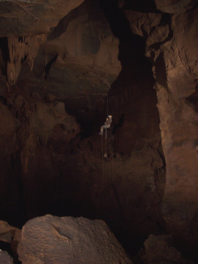
An hour later, we were at the cave and gearing up. Rick and Heather rigged the entrance, and the vertical team dropped in and headed on their way. Our horizontal team rappelled in and started traveling at approximately 10:15. We headed down the Corkscrew, down the 90 foot "rappel" (which Miles and Rick arm-wrapped, I chose to use my microrack instead), through Bob's Big Break Borehole, and turned right to the JD Rotunda drops.

I visited Hells Kitchen last year, and don't remember taking the same route which we took today. We encountered the vertical team waiting for us after losing the way on. Miles led us through a series of stoops and crawls, over a 6 foot deep incision in the floor, and we turned sharp left and up instead of out over a pit (EAS?) with a good echo. An 8 foot climb-up popped us out into a junction room with several leads going off from it.

After a quick break, the six of us headed to Hells Kitchen, then up through the dry, gypsum-encrusted FRK and SPN surveys. Yvonne pointed out a crevice in the floor at the SPN survey where dropped rocks appear to bounce down for many tens of feet. The SPN passage kept getting smaller and smaller until we were finally popped out into a deep but narrow canyon passage, MDS. I believe that it took us around 4.5 hours to get back to this section.

Our team started surveying a lead at MDS28, a sloping bank of rather large cobbles up and to the right of the main canyon. We called the survey MDR (Miles, Dave, Rick). The passage first got rather low, and then opened up to a vertical-walled chamber 15 - 20 feet high, 6 feet wide and 20 feet long. I climbed up to check a potential high lead and a good fist-sized hand hold came loose and bounced off my head; this high route was too tight, but we would later survey this upper level from another lead.

We surveyed down into a canyon slot in the floor, Rick and I both trying several ways before finally squeezing our way through. We were in a small breakdown chamber walled by a delicately-balanced slope of large cobbles and breakdown debris. An enlarged vertical joint in the floor dropped at least 8 feet, but several minutes of hammering opened it up enough to see that it'd be a mining project to push it for little gain.

From the "big" chamber, we followed a second canyon lead up over more cobbles to a tall and narrow canyon. Rick did an impressive squeeze/climb up over a surfboard-shaped rock to an even higher, vertical-walled chamber. We did a survey shot through an impassable crevice rather than try to survey up the climb. From this higher small chamber, I climbed up to peer into another even higher passage, which was walled by terminal breakdown and cobbles. MDS28 lead killed, approximately 160 feet surveyed.

We headed back out into the main MDS canyon and proceeded to knock rocks down towards the unsuspecting vertical team below. At their request ("NOOO ROOOCKS!") we halted until they could take cover, then leapfrogged them to check out a low, tight lead up at the canyon ceiling. Though discontinuous with the previous lead, we called the entire day's survey MDR. Rick headed in to scope it out, and discovered (as per Miles's intuition) and very nice pit. I headed in next with our 50 foot tape, dropped it down and could see that it was too short to reach the bottom (my estimate was 60 - 70 feet deep). Hmmm. We interrupted the other team, swapped our 50 foot tape for their 100 foot tape, and Miles crawled in to tape the pit - 51.5 feet. Hrmph. Lead killed, approximately 70 feet surveyed (mostly vertical).

It was at this point that I noticed something particularly odd about Rick. Every time that we'd take a short break, he'd dig into his modestly-sized pack and produce a roast beef sandwich. He appeared to be on his 6th or 7th sandwich of the evening, with no end in sight. I'm not sure which was more impressive - his appetite, or his "bottomless" pack.

Our group back-tracked further along the main MDS canyon to MDS14, where the canyon meanders low and takes a different route than the higher canyon level. We surveyed downstream through the narrow and frequently-awkward lower canyon. This passage meanders very regularly and very tightly, our shots averaged about 9 - 10 feet per bend. The passage was very dry, and gypsum crystal was abundant on much of the walls. We were forced down to floor level, stooping, and generally confined to a small space. Shot after shot, the meandering canyon was relentless, eventually pinching so narrow that a rather modest-sized piece of breakdown prevented us from continuing. Miles, from the upstream direction, climbed up to the ceiling, where fragmented rock rained down on us from above. He was unable to continue on at this level. We shot 15 stations for around 125 feet, lead killed.

We communicated with the vertical team, below us on the SRT level, and tried to work out a plan for derigging their pits and give them directions to head out. Communication problems abounded, and it was eventually decided that we'd abandon our final lead and follow them out. We descended one of their pits, rigged with 9mm PMI on a bouncy webbing runner. The rope rubs at two spots near the top, and should probably be padded if it is to remain rigged.

After a ledge traverse and a bit of boulder hopping, we were quickly back to the junction room - having cut out the entire KNF, FRK, Hells Kitchen area - a nice time-saver. We headed back out towards the JD Rotunda climbs and followed our route towards the entrance. At the 90 foot slope, Miles and Rick took the bypass climb, while I ascended the slope - we reached the top at almost exactly the same time. I'm not a fan of the bypass climb, and was feeling pooped at this point.

At the entrance room (around 4am), we found that the vertical team had already ascended, and the North team (Bob, Jo, Cullen) was now starting to exit the cave. I needed a rest before climbing out, so we let them climb first. A 10-minute nap completely refreshed me, and Rick and I frogged out quickly after Bob and Jo had reached the top, leaving Miles to ascend out last. I was topside by 05:15, just as night was turning to dawn. Since Brian's "lost in borehole" photo team was still in the cave, I opted to stay at the entrance until they had exited. I waited patiently for them (with both eyes closed) until they emerged after 07:00 Sunday morning, helped them derig the ropes, and we went to breakfast again at the 4-U (where both Brian and Mary fell asleep at the table). I drove to Spruce Knob to get the WV highpoint, where I took another nap before driving back home to Morgantown.

We surveyed around 350 feet, killed 3 leads, and were underground for approximately 19 hours.

Tuesday, March 27, 2007

[trip] Pendleton Caving - Sinnett, Sites

In celebration of Spring Break, John Harman, Josh Flaugher, Cullen Hencke, and Dave Riggs spent a few days caving in Pendleton County, WV.

On Tuesday, March 27, we met up at John's house in Germany Valley (Schoolhouse Cave is literally in his front yard) and were joined by Chris Eleyette. The five of us took a trip into Sinnett-Thorn Mountain Cave, which is gated and requires access through the Sinnett-Thorn Cave Conservancy. John, Josh, and Cullen have recently made several trips into Sinnett-Thorn, but it was Chris's and my first visit.

We went into the gated Sinnett Cave entrance and followed the main passage, which mostly consisted of very dry canyon passage. We then climbed up the spiraling Silo into the massive, strike-oriented big room. The big room is completely floored with breakdown, and has a steeply sloping ceiling following the dip of the limestone. The walls of the big room are lined with fossil brachiopods, meaning that it is likely formed in the Corriganville member of the Helderberg (similar to Cave Mountain Cave). This long room has a very impressive volume, which hints at some large passage hidden beneath the breakdown.


CMI-sponsored professional caver Cullen Hencke climbs The Silo in Sinnett Cave. Photo: John Harman.

After playing around in the big room for a bit, we attempted the Thorn Mountain Cave connection. A climb up from the big room leads to a wet and muddy uphill crawl - which some kind soul has floored with plastic - with the most powerful cave wind that I've ever felt. A low and wide, upsloping room leads to a tiny triangular crawlway about 15 feet long. This passage supposedly leads to the Sinnett Annex, but neither John nor I could fit, thus nixing our Thorn Mountain connection attempt.

We attempted to push two other tight passages near the big room, looking for a rumoured "lost" connection to the waterfall, but were unsuccessful. We then climbed back down the silo and hopped down into a stream canyon, going upstream to the waterfall room. After much searching, we located the passage up at waterfall level, which requires a very low crawl after a sketchy climb. After a full day caving, we headed back out through more crawls than I remembered on the way in.


Josh, Cullen, Chris, John, and Dave outside the gated entrance to Sinnett-Thorn Mountain Cave. Photo: John Harman.

After a warm dinner in the sprawling metropolis of Franklin (home of CMI!), we headed back to John's and camped on his beautiful property in Germany Valley. We did a bit of covert rappelling that night, and on Wednesday morning got a tour of some of the incredible sinkholes and karst features of Germany Valley.


Midnight rappelling in a secret Germany Valley pit. Photo: John Harman.

We headed back to Franklin and met up with Jessica Morning, then headed to Sites Cave. A brisk hike up the mountain on a well-marked trail leads to the gaping entrance to Sites Cave, a very popular vertical cave since the 1950's. We rigged from a tree high up on the hill, which gave a nice free drop down the entrance pit. I rappelled down first, with rope bag in tow - it repeatedly twisted around the rope on the way down, causing much fumbling and cursing. While Sites is nearly 300 foot deep, the rappel is about 180 feet interrupted several times by sloping dirt ledges - the deepest purely vertical drop is just over 100 feet. The sloping passages appear to roughly follow the steep dip of the Helderberg.


Dave Riggs on rappel at Sites Cave. Photo: John Harman.

At the bottom is a nice strike-oriented chamber with lots of formations and many sleeping bats. We had heard that a dead deer at the bottom was cause for alarm, but the smell had worked its way out by the time we visited the cave. The climb back out took plenty of time, and the weather turned slightly worse - occasionally spitting light rain on those waiting at the top. The dreaded "finger" only grabbed the rope once or twice, but nobody got stuck by it. It turned out to be a great trip, and we followed it up with another (better) meal in Franklin, then parted ways. I made it back to Morgantown by midnight and slept like a brick after two full days of caving.


Cullen Hencke and Jessica Morning in the decorated lower room of Sites Cave. Photo: John Harman.

Monday, August 07, 2006

[trip] GVKS Survey 2

Another survey trip for the GVKS again last week, this one 16 hours with zero feet surveyed!

Terry McClanathan and I ascended the Southwest Dome, currently the tallest known pit in WV, to get an accurate measurement of its height. There's a rebelay about 185' off the floor; it's at a small loft so you can get off rope onto your feet when you cross the rebelay. The loft is large enough for a couple people to stand and keep clear of rockfall from above. You pendulum about 10' to the left and continue upwards, the top of the dome slowly getting narrower and narrower to the point that there's a nice "helmet check" shelf to avoid near the top.

The very top of the dome is really just a mud-floored shelf; another pit is visible to the left, and there's no obvious passage from there, though I never unclipped from the safety line to check. There were several small solutional passages intersecting the pit on opposite wall on the way up, but no water was noted from below the rebelay to the top of the dome.

The rebelay pendulum was a bit tricky on the way down, but from there you've got a straight rappel down the rest of the pit - at least, you would if the rope weren't so muddy. I had to feed my microrack most of the way down because it was so gritty! The last 75' of rope seemed clean, presumably from the small amount of spray present (we did not get wet on rope). The pit measured 247' from bolt to floor, 240' from the upper ledge.

It was amazing to follow the bolt route up this huge dome, what an incredible effort it must have been!


Frogging up the tallest known dome in WV... 20' off the floor, only 220' left to go!

This cave is NOT open to the general caving public. It is only open for survey by the Germany Valley Karst Survey under contract to Greer Industries. OTHER CAVING IS STRICTLY FORBIDDEN.

Photos by Brian Masney